|
search place name
|
||
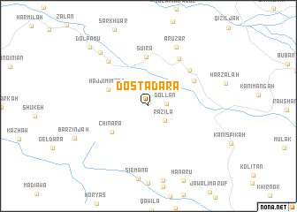
Dosta Dara (As Sulaymānīyah, Iraq)Dosta Dara is a town in the As Sulaymānīyah region of Iraq. An overview map of the region around Dosta Dara is displayed below.
regional and 3d topo map of Dosta Dara, Iraq ::
Dosta Dara airports ::
The nearest airport is SDG - Sanandaj, located 117.8 km east of Dosta Dara.
Other airports nearby include KSH - Bakhtaran Shahid Ashrafi Esfahani (186.1 km south east), Nearby towns ::
Gollān (1.9km east) //
Razila (2.5km south east) //
Ḩājjī Mimand (4.6km north west) //
Chināra (5.1km south west) //
Suira (6.2km north) //
Sarkan (5.7km north east) //
Galoz (6.2km north east) //
Dara Miana (6.8km north east) //
Parrazan (7.0km north west) //
Arūzār (7.9km north) //
Gueza Rash (8.4km north west) //
Dol Pāmū (9.6km north west) //
[all distances 'as the bird flies' and approximate]  Places with similar names to Dosta Dara, Iraq ::
// Deştedari (TR)
Disclaimer :: Information on this page comes without warranty of any kind |
||
|
Where is Dosta Dara? Elevation and coordinates ::
Latitude (lat): 35°34'52"N Longitude (lon): 45°46'45"E
Elevation (approx.): 1175m (map arrows pan, magnifying glasses zoom) |
||
|
Visiting Dosta Dara? Hotel/Accommodation ::
Book a hotel in Dosta Dara Travel Guide ::
Buy a travel guide for Iraq rental cars ::
car rental offers GPS waypoint ::
download a GPX waypoint (PoI) of Dosta Dara for your GPS receiver
|
||