|
search place name
|
||
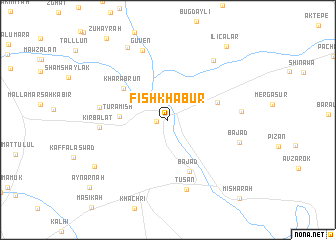
Fīsh Khābūr (Dahūk, Iraq)Fīsh Khābūr is a town in the Dahūk region of Iraq. An overview map of the region around Fīsh Khābūr is displayed below.
regional and 3d topo map of Fīsh Khābūr, Iraq ::
Fīsh Khābūr airports ::
The nearest airport is BAL - Batman, located 146.9 km north west of Fīsh Khābūr.
Other airports nearby include VAN - Van (176.7 km north east), Nearby towns ::
Khānīk (1.0km west) //
Ţurāmish (4.3km west) //
Derabon (4.8km north east) //
Kharāb Rūn (5.3km north west) //
Bājad (6.0km south) //
Kīr Balāţ (6.2km west) //
Al Marj al Akhḑar (6.2km west) //
Ţusān (7.9km south) //
Kūrīnah (6.6km east) //
Güven (8.1km north) //
Ovaköy (7.8km north east) //
Bājad (6.9km east) //
Kharāb Rashak (8.9km north west) //
‘Ayn ‘Akfat al Ma‘lajī (8.3km south west) //
Ilıcalar (9.7km north east) //
‘Ayn ‘Arnah (10.3km south west) //
Mishārah (10.9km south east) //
[all distances 'as the bird flies' and approximate]  Places with similar names to Fīsh Khābūr, Iraq :: Disclaimer :: Information on this page comes without warranty of any kind |
||
|
Where is Fīsh Khābūr? Elevation and coordinates ::
Latitude (lat): 37°4'5"N Longitude (lon): 42°22'42"E
Elevation (approx.): 352m (map arrows pan, magnifying glasses zoom) |
||
|
Visiting Fīsh Khābūr? Hotel/Accommodation ::
Book a hotel in Fīsh Khābūr Travel Guide ::
Buy a travel guide for Iraq rental cars ::
car rental offers GPS waypoint ::
download a GPX waypoint (PoI) of Fīsh Khābūr for your GPS receiver
|
||