|
search place name
|
||
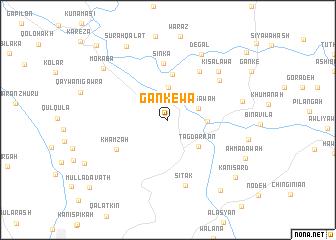
Gankēwa (As Sulaymānīyah, Iraq)Gankēwa is a town in the As Sulaymānīyah region of Iraq. An overview map of the region around Gankēwa is displayed below.
regional and 3d topo map of Gankēwa, Iraq ::
Gankēwa airports ::
The nearest airport is SDG - Sanandaj, located 146.0 km east of Gankēwa.
Other airports nearby include KSH - Bakhtaran Shahid Ashrafi Esfahani (213.3 km south east), Nearby towns ::
Bawākarwa (3.6km north) //
Shamsāwah (3.1km north east) //
Qal‘ah Chūlān (3.5km east) //
Tagdarrān (4.0km south east) //
Waza (5.1km north) //
Sinká (6.3km north) //
Bardazard (6.1km north east) //
Khamzah (5.7km south west) //
Mekukah (6.4km north east) //
Sītak (7.5km south) //
Kisalawa (7.1km north east) //
Degal (7.9km north east) //
Choarta (7.1km east) //
Mokaba (8.2km north west) //
Sūrah Qalāt (9.0km north west) //
Aḩmad Āwah (8.2km south east) //
Garradeh (9.2km south east) //
Kānī Sard (8.9km south east) //
Mullā Davath (10.4km south west) //
Zērtūk (10.6km north west) //
Sinjalah (10.4km north east) //
[all distances 'as the bird flies' and approximate] 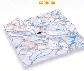 Places with similar names to Gankēwa, Iraq ::
// Cangawa (PH)
// Kānī Kawa (IQ)
// Kānī Kawah (IQ)
// Kānī Kawah (IQ)
// Kanigowo (PL)
// Kanigowo (PL)
// Kańkowo (PL)
// Konikowo (PL)
// Kunkowa (PL)
// Koungwo (BF)
Disclaimer :: Information on this page comes without warranty of any kind |
||
|
Where is Gankēwa? Elevation and coordinates ::
Latitude (lat): 35°42'4"N Longitude (lon): 45°29'58"E
Elevation (approx.): 957m (map arrows pan, magnifying glasses zoom) |
||
|
Visiting Gankēwa? Hotel/Accommodation ::
Book a hotel in Gankēwa Travel Guide ::
Buy a travel guide for Iraq rental cars ::
car rental offers GPS waypoint ::
download a GPX waypoint (PoI) of Gankēwa for your GPS receiver
|
||