|
search place name
|
||
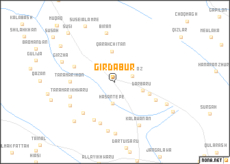
Girdābur (As Sulaymānīyah, Iraq)Girdābur is a town in the As Sulaymānīyah region of Iraq. An overview map of the region around Girdābur is displayed below.
regional and 3d topo map of Girdābur, Iraq ::
Girdābur airports ::
The nearest airport is SDG - Sanandaj, located 171.9 km east of Girdābur.
Other airports nearby include KSH - Bakhtaran Shahid Ashrafi Esfahani (233.6 km south east), Nearby towns ::
Yālānqoz (2.5km east) //
Ḩasan Tepe (3.5km south) //
Dārbarū (3.9km east) //
Qarah Chītān (5.0km north) //
Bīskandī (5.0km south east) //
Charmagah (5.9km north west) //
Gurgayar (6.8km south west) //
Bāgh (7.0km south) //
Dār Tū (6.1km south east) //
Hājīāwā-i Khawārū (6.6km south west) //
Taramār-i Kōn (6.0km west) //
Taramār-i Khwāru (6.3km west) //
Qalkand (8.0km south) //
Bīrān (8.1km north) //
Kālawānān (7.8km south east) //
Tramal Sifla (7.1km south west) //
Chāqizh (8.5km south) //
Kānī Munim (7.8km south east) //
Zāyir (8.4km south west) //
Girzha (7.8km north west) //
Yārānbagī (9.3km north west) //
Sūsi (10.1km north west) //
[all distances 'as the bird flies' and approximate] 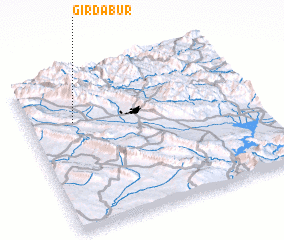
Disclaimer :: Information on this page comes without warranty of any kind |
||
|
Where is Girdābur? Elevation and coordinates ::
Latitude (lat): 35°42'5"N Longitude (lon): 45°11'56"E
Elevation (approx.): 850m (map arrows pan, magnifying glasses zoom) |
||
|
Visiting Girdābur? Hotel/Accommodation ::
Book a hotel in Girdābur Travel Guide ::
Buy a travel guide for Iraq rental cars ::
car rental offers GPS waypoint ::
download a GPX waypoint (PoI) of Girdābur for your GPS receiver
|
||