|
search place name
|
||
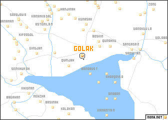
Golak (As Sulaymānīyah, Iraq)Golak is a town in the As Sulaymānīyah region of Iraq. An overview map of the region around Golak is displayed below.
regional and 3d topo map of Golak, Iraq ::
Golak airports ::
The nearest airport is TBZ - Tabriz Intl, located 246.3 km north east of Golak.
Nearby towns ::
(( Bārabust )) (3.3km south) //
Qūrījah (3.0km south west) //
Hanjīrah (4.2km north east) //
Boskin (4.9km north east) //
(( Bāz Musiyān )) (5.6km south east) //
(( Tōbah Kārān )) (5.2km south east) //
Qūrah Kū (5.7km north east) //
Rāniyah (6.8km north) //
Chuar Qurna (5.6km west) //
Saydā Faqīrah (6.7km north) //
Kunaşak (8.0km north) //
(( Kharq Risa )) (7.5km south east) //
(( Qūrah Shīnah )) (9.6km south east) //
(( ‘Arabān )) (10.3km south east) //
Astērīlān (9.9km north west) //
[all distances 'as the bird flies' and approximate]  Places with similar names to Golak, Iraq ::
Disclaimer :: Information on this page comes without warranty of any kind |
||
|
Where is Golak? Elevation and coordinates ::
Latitude (lat): 36°11'41"N Longitude (lon): 44°53'14"E
Elevation (approx.): 497m (map arrows pan, magnifying glasses zoom) |
||
|
Visiting Golak? Hotel/Accommodation ::
Book a hotel in Golak Travel Guide ::
Buy a travel guide for Iraq rental cars ::
car rental offers GPS waypoint ::
download a GPX waypoint (PoI) of Golak for your GPS receiver
|
||