|
search place name
|
||
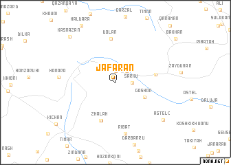
Ja‘farān (As Sulaymānīyah, Iraq)Ja‘farān is a town in the As Sulaymānīyah region of Iraq. An overview map of the region around Ja‘farān is displayed below.
regional and 3d topo map of Ja‘farān, Iraq ::
Ja‘farān airports ::
The nearest airport is SDG - Sanandaj, located 152.6 km east of Ja‘farān.
Other airports nearby include KSH - Bakhtaran Shahid Ashrafi Esfahani (197.7 km south east), Nearby towns ::
Tākān (1.9km north) //
Ţūfān (2.4km north east) //
Sarkū (2.3km east) //
Gōshān (4.5km south east) //
Zhāla (6.5km south) //
Zhālah (6.5km south) //
Qarah Dāgh (5.5km east) //
Dolan (7.1km north) //
Ribāţ (8.4km south) //
Astēl [2] (8.8km south east) //
Kasnazan (9.6km north west) //
[all distances 'as the bird flies' and approximate] 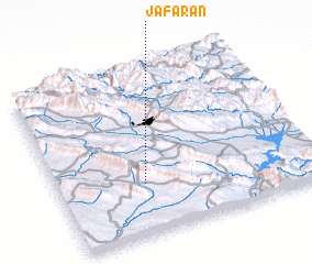 Places with similar names to Ja‘farān, Iraq ::
// Javerne (CH)
// João Frino (PT)
// Javorani (BA)
// Javorine (BA)
// Jafarini (TZ)
// Gīvarān (IR)
// Gīvarān (IR)
// Javārān (IR)
// Jafrān (PK)
// Jo Fourneau (HT)
Disclaimer :: Information on this page comes without warranty of any kind |
||
|
Where is Ja‘farān? Elevation and coordinates ::
Latitude (lat): 35°18'0"N Longitude (lon): 45°20'0"E
Elevation (approx.): 939m (map arrows pan, magnifying glasses zoom) |
||
|
Visiting Ja‘farān? Hotel/Accommodation ::
Book a hotel in Ja‘farān Travel Guide ::
Buy a travel guide for Iraq rental cars ::
car rental offers GPS waypoint ::
download a GPX waypoint (PoI) of Ja‘farān for your GPS receiver
|
||