|
search place name
|
||
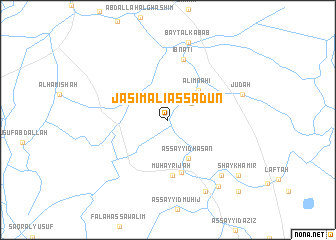
Jāsim ‘Alī as Sa‘dūn (Wāsiţ, Iraq)Jāsim ‘Alī as Sa‘dūn is a town in the Wāsiţ region of Iraq. An overview map of the region around Jāsim ‘Alī as Sa‘dūn is displayed below.
regional and 3d topo map of Jāsim ‘Alī as Sa‘dūn, Iraq ::
Jāsim ‘Alī as Sa‘dūn airports ::
The nearest airport is BSR - Basrah Intl, located 257.5 km south east of Jāsim ‘Alī as Sa‘dūn.
Nearby towns ::
‘Ābid ‘Alī (2.9km north east) //
‘Alīm Nāhī (4.4km north east) //
As Sayyid Ḩasan (4.7km south east) //
Al Muwaffaqīyah (6.0km south) //
Muḩayrījah (6.2km south) //
Ibn Ātī (6.9km north) //
Zinābīyah (8.0km south east) //
Jūdah (7.6km east) //
Bayt al Kabāb (8.9km north) //
Zuwayyah (8.8km south east) //
Ḩusayn al ‘Alī (8.8km south east) //
Shaykh ‘Āmir (9.1km south east) //
Qal‘at Muḩammad as Sulaymān (10.4km south east) //
[all distances 'as the bird flies' and approximate]  Places with similar names to Jāsim ‘Alī as Sa‘dūn, Iraq :: Disclaimer :: Information on this page comes without warranty of any kind |
||
|
Where is Jāsim ‘Alī as Sa‘dūn? Elevation and coordinates ::
Latitude (lat): 32°19'20"N Longitude (lon): 45°54'45"E
Elevation (approx.): 19m (map arrows pan, magnifying glasses zoom) |
||
|
Visiting Jāsim ‘Alī as Sa‘dūn? Hotel/Accommodation ::
Book a hotel in Jāsim ‘Alī as Sa‘dūn Travel Guide ::
Buy a travel guide for Iraq rental cars ::
car rental offers GPS waypoint ::
download a GPX waypoint (PoI) of Jāsim ‘Alī as Sa‘dūn for your GPS receiver
|
||