|
search place name
|
||
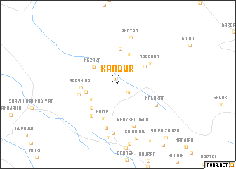
Kandūr (Arbīl, Iraq)Kandūr is a town in the Arbīl region of Iraq. An overview map of the region around Kandūr is displayed below.
regional and 3d topo map of Kandūr, Iraq ::
Kandūr airports ::
The nearest airport is TBZ - Tabriz Intl, located 236.5 km north east of Kandūr.
Other airports nearby include VAN - Van (243.8 km north west), Nearby towns ::
Tālinān (1.8km south east) //
Mezaka (4.1km north west) //
Harutiyān (4.1km south west) //
Binmērda (5.0km north) //
Garawān Zhuru (4.5km north east) //
Tutmara (4.2km west) //
Sartik (5.0km south west) //
Fāqiyān (5.7km north) //
Sārshīna (4.7km west) //
Khitē (5.8km south) //
Garawān (5.3km north east) //
Tārāvān (5.2km west) //
Ashkawta (6.1km south west) //
Malākān (5.8km south east) //
Shaykh Wāsān (6.9km south) //
Bērō (7.1km south) //
Ākoyān (7.6km north) //
Ţūţmah (7.7km south) //
Tūtmah (8.5km south) //
Kānī Bard (8.9km south) //
Bēlāwa (9.8km south east) //
Shīra-i Zhūrū (10.4km south east) //
[all distances 'as the bird flies' and approximate] 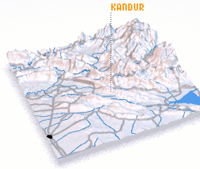 Places with similar names to Kandūr, Iraq ::
Disclaimer :: Information on this page comes without warranty of any kind |
||
|
Where is Kandūr? Elevation and coordinates ::
Latitude (lat): 36°29'31"N Longitude (lon): 44°32'5"E
Elevation (approx.): 1126m (map arrows pan, magnifying glasses zoom) |
||
|
Visiting Kandūr? Hotel/Accommodation ::
Book a hotel in Kandūr Travel Guide ::
Buy a travel guide for Iraq rental cars ::
car rental offers GPS waypoint ::
download a GPX waypoint (PoI) of Kandūr for your GPS receiver
|
||