|
search place name
|
||
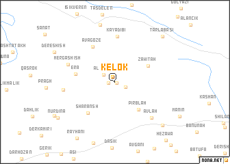
Kelok (Dahūk, Iraq)Kelok is a town in the Dahūk region of Iraq. An overview map of the region around Kelok is displayed below.
regional and 3d topo map of Kelok, Iraq ::
Kelok airports ::
The nearest airport is VAN - Van, located 137.2 km north of Kelok.
Other airports nearby include BAL - Batman (172.1 km north west), Nearby towns ::
Batroma (0.3km south east) //
Marsis (0.9km west) //
Korek (1.6km south east) //
Alānish (1.9km north west) //
Pirblah (5.4km south east) //
Zawītah (5.1km north east) //
Ēra (5.3km west) //
Sharānsh (6.2km south west) //
Ava Gōze (6.4km north west) //
Kayadibi (7.4km north) //
Mērga Shīsh (6.7km north west) //
Āvlah (7.5km south east) //
Pāchūrā (6.8km west) //
Chami Kork (9.3km south east) //
Tarlabaşı (9.7km north east) //
[all distances 'as the bird flies' and approximate] 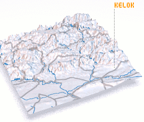 Places with similar names to Kelok, Iraq ::
Disclaimer :: Information on this page comes without warranty of any kind |
||
|
Where is Kelok? Elevation and coordinates ::
Latitude (lat): 37°16'59"N Longitude (lon): 42°53'19"E
Elevation (approx.): 1137m (map arrows pan, magnifying glasses zoom) |
||
|
Visiting Kelok? Hotel/Accommodation ::
Book a hotel in Kelok Travel Guide ::
Buy a travel guide for Iraq rental cars ::
car rental offers GPS waypoint ::
download a GPX waypoint (PoI) of Kelok for your GPS receiver
|
||