|
search place name
|
||
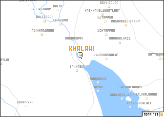
Khalāwī (Diyālá, Iraq)Khalāwī is a town in the Diyālá region of Iraq. An overview map of the region around Khalāwī is displayed below.
regional and 3d topo map of Khalāwī, Iraq ::
Nearby towns ::
Saw Kabīr (2.9km south) //
Nārīn Kūprī (4.0km north) //
‘Uyūn Khashālāt (4.6km east) //
Şaw Şaghīr (6.3km south east) //
Ūch Tappah (7.2km north east) //
Diyān (8.0km south) //
Askī Kūprī (8.9km north west) //
Aḩmad al Ḩaqq (8.0km north east) //
Uj Tappeh (9.6km north east) //
Qul Tappah (11.1km north west) //
[all distances 'as the bird flies' and approximate] 
Disclaimer :: Information on this page comes without warranty of any kind |
||
|
Where is Khalāwī? Elevation and coordinates ::
Latitude (lat): 34°18'0"N Longitude (lon): 44°56'0"E
Elevation (approx.): 96m (map arrows pan, magnifying glasses zoom) |
||
|
Visiting Khalāwī? Hotel/Accommodation ::
Book a hotel in Khalāwī Travel Guide ::
Buy a travel guide for Iraq rental cars ::
car rental offers GPS waypoint ::
download a GPX waypoint (PoI) of Khalāwī for your GPS receiver
|
||