|
search place name
|
||
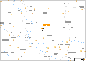
Kūnjirīn (As Sulaymānīyah, Iraq)Kūnjirīn is a town in the As Sulaymānīyah region of Iraq. An overview map of the region around Kūnjirīn is displayed below.
regional and 3d topo map of Kūnjirīn, Iraq ::
Kūnjirīn airports ::
The nearest airport is SDG - Sanandaj, located 152.0 km south east of Kūnjirīn.
Other airports nearby include KSH - Bakhtaran Shahid Ashrafi Esfahani (223.3 km south east), Nearby towns ::
Māwīn (2.7km north west) //
Bētwāt (3.3km south) //
Warāz (4.2km south east) //
Sūrah Qalāt (5.1km south west) //
Bānālah (5.1km north west) //
Sinká (6.4km south) //
Mīrāwā (6.5km north) //
Degal (6.9km south east) //
Zērtūk (6.7km south west) //
Waza (7.8km south) //
Kunamāsī (6.7km west) //
Bardazard (8.4km south east) //
Mokaba (8.3km south west) //
Sarbast (8.6km north west) //
Kārēza (7.7km south west) //
Kisalawa (9.3km south east) //
Mekukah (10.2km south east) //
Rashah Kān (10.2km north east) //
[all distances 'as the bird flies' and approximate] 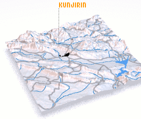 Places with similar names to Kūnjirīn, Iraq ::
Disclaimer :: Information on this page comes without warranty of any kind |
||
|
Where is Kūnjirīn? Elevation and coordinates ::
Latitude (lat): 35°48'54"N Longitude (lon): 45°29'5"E
Elevation (approx.): 1080m (map arrows pan, magnifying glasses zoom) |
||
|
Visiting Kūnjirīn? Hotel/Accommodation ::
Book a hotel in Kūnjirīn Travel Guide ::
Buy a travel guide for Iraq rental cars ::
car rental offers GPS waypoint ::
download a GPX waypoint (PoI) of Kūnjirīn for your GPS receiver
|
||