|
search place name
|
||
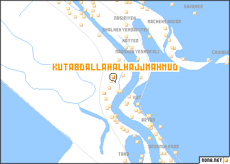
Kūt ‘Abd Allāh al Ḩājj Maḩmūd (Al Başrah, Iraq)Kūt ‘Abd Allāh al Ḩājj Maḩmūd is a town in the Al Başrah region of Iraq. An overview map of the region around Kūt ‘Abd Allāh al Ḩājj Maḩmūd is displayed below.
regional and 3d topo map of Kūt ‘Abd Allāh al Ḩājj Maḩmūd, Iraq ::
Kūt ‘Abd Allāh al Ḩājj Maḩmūd airports ::
The nearest airport is ABD - Abadan, located 27.2 km north west of Kūt ‘Abd Allāh al Ḩājj Maḩmūd.
Other airports nearby include BSR - Basrah Intl (81.3 km north west), MRX - Bandar Mahshahr Mahshahr (85.6 km north east), KWI - Kuwait Intl (111.6 km south), AWZ - Ahwaz (134.8 km north), Nearby towns ::
Kūt ‘Abd Allāh (0.5km west) //
Al Ḩājj Maḩmūd (1.3km south west) //
Al Ḩājj Maḩmūd (1.5km south) //
Kūt ad Dawārijah (1.6km north east) //
Kūt Zāʼir ‘Alī (1.7km south east) //
Ad Dawrah (2.4km south west) //
Ad Dūrah (2.4km south west) //
Qaryat Mu‘āwiyah (2.5km north east) //
Al Khushnām (2.7km north east) //
Shalhat Mu‘āwiyah (3.0km north east) //
Abū ‘Iqāb (3.1km south west) //
Bahmanbār (3.1km south east) //
Ma‘yawīyah (3.2km north east) //
Kūt al Khalīfah (3.6km north) //
Bāgāb Qaryeh (3.8km south east) //
Kūt an Najdī (4.0km south) //
Abū ‘Oqāb (4.0km south east) //
Khosrowābād (3.7km east) //
Kūt Shannūf (4.4km south) //
Kūt (4.9km south east) //
Abū Shakar (4.9km south east) //
Naqsheh-ye Shomālī (5.0km north east) //
Manāzil al Ghībānī (5.5km south) //
Kūt-e Bālā (5.5km south east) //
Al Ḩājj Ashūr (5.8km south) //
Ḩayyer-e Do (5.9km north) //
Mo‘āvīyeh (5.9km north) //
Qaryat al Ḩājj ‘Āshūr (6.2km south) //
Hayyer (6.1km north) //
[all distances 'as the bird flies' and approximate]  Places with similar names to Kūt ‘Abd Allāh al Ḩājj Maḩmūd, Iraq :: Disclaimer :: Information on this page comes without warranty of any kind |
||
|
Where is Kūt ‘Abd Allāh al Ḩājj Maḩmūd? Elevation and coordinates ::
Latitude (lat): 30°9'58"N Longitude (lon): 48°22'59"E
Elevation (approx.): -2m (map arrows pan, magnifying glasses zoom) |
||
|
Visiting Kūt ‘Abd Allāh al Ḩājj Maḩmūd? Hotel/Accommodation ::
Book a hotel in Kūt ‘Abd Allāh al Ḩājj Maḩmūd Travel Guide ::
Buy a travel guide for Iraq rental cars ::
car rental offers GPS waypoint ::
download a GPX waypoint (PoI) of Kūt ‘Abd Allāh al Ḩājj Maḩmūd for your GPS receiver
|
||