|
search place name
|
||
Maftūl (Şalāḩ ad Dīn, Iraq)Maftūl is a town in the Şalāḩ ad Dīn region of Iraq. An overview map of the region around Maftūl is displayed below.
regional and 3d topo map of Maftūl, Iraq ::
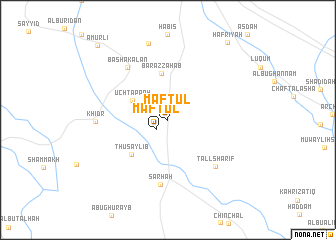
Nearby towns ::
Maftūl (1.6km south west) //
Ūch Tappah (3.9km north west) //
Bar az Zahab (5.2km north) //
Thuşaylib (5.1km south west) //
Sārhah (7.2km south) //
Bāshākalān (6.9km north west) //
Tall Sharīf (6.8km south east) //
Khiḑr (6.7km west) //
Kutah Burūn Jadīd (8.7km north) //
Ḩafrīyah (10.2km north east) //
Amurlī (10.5km north west) //
[all distances 'as the bird flies' and approximate] 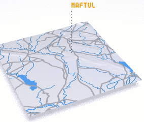 Places with similar names to Maftūl, Iraq ::
// Maftūl (IQ)
// Maftūl (IQ)
// Maftūl (IQ)
// Mafatle (ZA)
// Moffitt Hill (US)
// Maiphatelo (BW)
// Mafutala (CD)
// Mafutala (CD)
// Mughaydilah (SY)
Disclaimer :: Information on this page comes without warranty of any kind |
||
|
Where is Maftūl? Elevation and coordinates ::
Latitude (lat): 34°38'51"N Longitude (lon): 44°39'11"E
Elevation (approx.): 150m (map arrows pan, magnifying glasses zoom) |
||
|
Visiting Maftūl? Hotel/Accommodation ::
Book a hotel in Maftūl Travel Guide ::
Buy a travel guide for Iraq rental cars ::
car rental offers GPS waypoint ::
download a GPX waypoint (PoI) of Maftūl for your GPS receiver
|
||