|
search place name
|
||
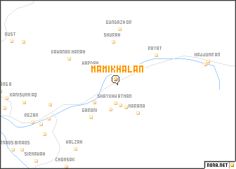
Mām-ī Khalān (Arbīl, Iraq)Mām-ī Khalān is a town in the Arbīl region of Iraq. An overview map of the region around Mām-ī Khalān is displayed below.
regional and 3d topo map of Mām-ī Khalān, Iraq ::
Mām-ī Khalān airports ::
The nearest airport is TBZ - Tabriz Intl, located 202.5 km north east of Mām-ī Khalān.
Other airports nearby include VAN - Van (246.3 km north west), Nearby towns ::
Shaykh Watmān (2.9km south) //
Bandayzān (3.3km south) //
Dōlahband (3.1km north west) //
Khush Khān (3.8km south) //
Shaykhān (4.1km south) //
Nāwpirdān (4.1km south west) //
Wardah (4.1km north west) //
Marana (5.2km south east) //
Garoni (6.2km south west) //
Shūrah (6.8km north) //
Rāyāt (6.7km north east) //
Gunda Zhor (8.7km north) //
Kawana Khānah (7.4km north west) //
[all distances 'as the bird flies' and approximate] 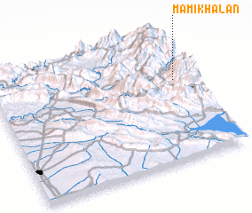 Places with similar names to Mām-ī Khalān, Iraq ::
// Māmkhālan (IQ)
Disclaimer :: Information on this page comes without warranty of any kind |
||
|
Where is Mām-ī Khalān? Elevation and coordinates ::
Latitude (lat): 36°38'33"N Longitude (lon): 44°55'2"E
Elevation (approx.): 1418m (map arrows pan, magnifying glasses zoom) |
||
|
Visiting Mām-ī Khalān? Hotel/Accommodation ::
Book a hotel in Mām-ī Khalān Travel Guide ::
Buy a travel guide for Iraq rental cars ::
car rental offers GPS waypoint ::
download a GPX waypoint (PoI) of Mām-ī Khalān for your GPS receiver
|
||