|
search place name
|
||
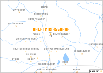
Qal‘at Mirias Sakhr (Dhī Qār, Iraq)Qal‘at Mirias Sakhr is a town in the Dhī Qār region of Iraq. An overview map of the region around Qal‘at Mirias Sakhr is displayed below.
regional and 3d topo map of Qal‘at Mirias Sakhr, Iraq ::
Qal‘at Mirias Sakhr airports ::
The nearest airport is BSR - Basrah Intl, located 189.0 km south east of Qal‘at Mirias Sakhr.
Nearby towns ::
Qal‘at Sayyid Şāfī (3.2km east) //
Suwayj al Muşayfī (3.7km south west) //
Qal‘at Miryās (3.7km south west) //
Sirḩān (4.7km west) //
Ḩasan (5.6km south) //
Qal‘at Muḩammad as Salmān (5.8km south) //
Sūq Abū Hawā (6.9km south) //
‘Ajīl ar Radnān (7.7km south) //
Imām Sayyid Yūsuf (7.3km north west) //
Manthar Miz‘al (8.1km north west) //
Mubārah (9.1km south west) //
Zulaymāt (9.7km south west) //
[all distances 'as the bird flies' and approximate]  Places with similar names to Qal‘at Mirias Sakhr, Iraq :: Disclaimer :: Information on this page comes without warranty of any kind |
||
|
Where is Qal‘at Mirias Sakhr? Elevation and coordinates ::
Latitude (lat): 31°38'0"N Longitude (lon): 46°8'0"E
Elevation (approx.): 7m (map arrows pan, magnifying glasses zoom) |
||
|
Visiting Qal‘at Mirias Sakhr? Hotel/Accommodation ::
Book a hotel in Qal‘at Mirias Sakhr Travel Guide ::
Buy a travel guide for Iraq rental cars ::
car rental offers GPS waypoint ::
download a GPX waypoint (PoI) of Qal‘at Mirias Sakhr for your GPS receiver
|
||