|
search place name
|
||
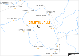
Qal‘at Mujallī (Dhī Qār, Iraq)Qal‘at Mujallī is a town in the Dhī Qār region of Iraq. An overview map of the region around Qal‘at Mujallī is displayed below.
regional and 3d topo map of Qal‘at Mujallī, Iraq ::
Qal‘at Mujallī airports ::
The nearest airport is BSR - Basrah Intl, located 208.2 km south east of Qal‘at Mujallī.
Nearby towns ::
Qal‘at Ghudayyir (5.2km north) //
Fashākh (4.7km east) //
Sayyid Ţarfah (5.2km west) //
Ālbū Ḩamzah (5.7km east) //
As Sayyid Muḩammad (6.6km west) //
Qal‘at Sukkar (7.8km north east) //
Thāmir al Mazbūd (8.8km north west) //
Ar Rifā‘ī (11.2km south east) //
[all distances 'as the bird flies' and approximate] 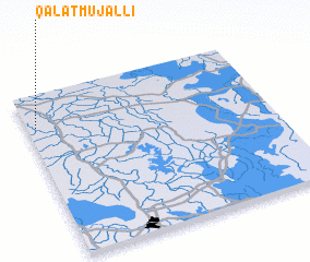 Places with similar names to Qal‘at Mujallī, Iraq :: Disclaimer :: Information on this page comes without warranty of any kind |
||
|
Where is Qal‘at Mujallī? Elevation and coordinates ::
Latitude (lat): 31°48'0"N Longitude (lon): 46°2'0"E
Elevation (approx.): 11m (map arrows pan, magnifying glasses zoom) |
||
|
Visiting Qal‘at Mujallī? Hotel/Accommodation ::
Book a hotel in Qal‘at Mujallī Travel Guide ::
Buy a travel guide for Iraq rental cars ::
car rental offers GPS waypoint ::
download a GPX waypoint (PoI) of Qal‘at Mujallī for your GPS receiver
|
||