|
search place name
|
||
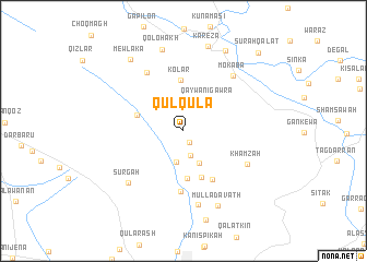
Qulqula (As Sulaymānīyah, Iraq)Qulqula is a town in the As Sulaymānīyah region of Iraq. An overview map of the region around Qulqula is displayed below.
regional and 3d topo map of Qulqula, Iraq ::
Qulqula airports ::
The nearest airport is SDG - Sanandaj, located 155.5 km east of Qulqula.
Other airports nearby include KSH - Bakhtaran Shahid Ashrafi Esfahani (220.7 km south east), Nearby towns ::
Chālgah (1.2km south east) //
Kānī Klāw (2.6km south) //
Hanārān Khwārū (3.2km south) //
Kānī Gurān (3.6km south) //
Qaywān-i Gawra (3.6km north east) //
Fadāyal (4.9km south) //
Hanārān Zhūrū (4.2km north west) //
Tūwaspī (4.9km south) //
Kolar (5.2km north) //
Dēkōn (5.5km south east) //
Chaqchaq (6.2km south) //
Sangar (6.7km north west) //
Khamzah (6.3km south east) //
Mokaba (6.9km north east) //
Kānī Bardīnah (7.7km south) //
Sūrgah (7.0km south west) //
Mullā Davath (8.2km south) //
Qōlohākh (8.5km north) //
Kārēza (8.8km north) //
Mēwlaka (8.5km north west) //
Zērtūk (8.9km north east) //
Sūrah Qalāt (10.1km north east) //
[all distances 'as the bird flies' and approximate] 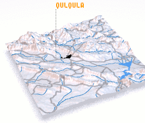 Places with similar names to Qulqula, Iraq ::
// Kalağaylı (AZ)
// Gulgul (ER)
// Qılıçlı (AZ)
// Qılıçlı (AZ)
// Culiculi (PH)
// Gligli (PH)
// Guilaguila (PH)
// Guilguila (PH)
// Guiliguili (PH)
// Kalukalu (PH)
Disclaimer :: Information on this page comes without warranty of any kind |
||
|
Where is Qulqula? Elevation and coordinates ::
Latitude (lat): 35°42'8"N Longitude (lon): 45°23'20"E
Elevation (approx.): 1027m (map arrows pan, magnifying glasses zoom) |
||
|
Visiting Qulqula? Hotel/Accommodation ::
Book a hotel in Qulqula Travel Guide ::
Buy a travel guide for Iraq rental cars ::
car rental offers GPS waypoint ::
download a GPX waypoint (PoI) of Qulqula for your GPS receiver
|
||