|
search place name
|
||
Şāliḩ Muḩammad (Baghdād, Iraq)Şāliḩ Muḩammad is a town in the Baghdād region of Iraq. An overview map of the region around Şāliḩ Muḩammad is displayed below.
regional and 3d topo map of Şāliḩ Muḩammad, Iraq ::
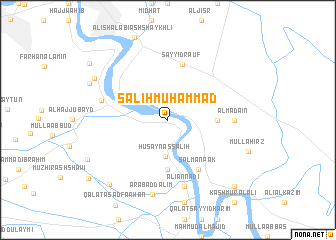
Nearby towns ::
‘Alī Chalabī (2.4km north west) //
Ḩusayn aş Şāliḩ (4.1km south) //
‘Abd al Jāsim (5.6km south) //
Muḩammad al Ḩusayn (4.7km east) //
Salmān al Qamar (4.7km east) //
Sayyid Raʼūf (6.3km north) //
Salmān Pāk (6.2km south east) //
Al Madāʼin (6.2km east) //
‘Alī an Nadī (7.6km south) //
Muḩammad Şāliḩ (6.6km west) //
‘Arab ad Dalīm (8.5km south) //
Nazl ‘Uşfūr (8.3km north west) //
Muḩammad al ‘Alī (8.4km north west) //
‘Alī al Khamīs (9.0km south west) //
Jalāl al Mutawallī (9.7km south east) //
‘Alī ad Dayyān (9.6km north west) //
‘Ubayd (9.9km south west) //
[all distances 'as the bird flies' and approximate] 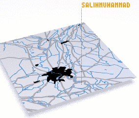 Places with similar names to Şāliḩ Muḩammad, Iraq ::
Disclaimer :: Information on this page comes without warranty of any kind |
||
|
Where is Şāliḩ Muḩammad? Elevation and coordinates ::
Latitude (lat): 33°9'0"N Longitude (lon): 44°33'0"E
Elevation (approx.): 40m (map arrows pan, magnifying glasses zoom) |
||
|
Visiting Şāliḩ Muḩammad? Hotel/Accommodation ::
Book a hotel in Şāliḩ Muḩammad Travel Guide ::
Buy a travel guide for Iraq rental cars ::
car rental offers GPS waypoint ::
download a GPX waypoint (PoI) of Şāliḩ Muḩammad for your GPS receiver
|
||