|
search place name
|
||
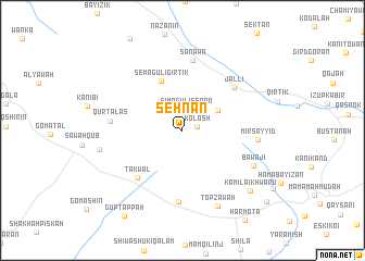
Sēhnān (Arbīl, Iraq)Sēhnān is a town in the Arbīl region of Iraq. An overview map of the region around Sēhnān is displayed below.
regional and 3d topo map of Sēhnān, Iraq ::
Sēhnān airports ::
The nearest airport is TBZ - Tabriz Intl, located 266.2 km north east of Sēhnān.
Nearby towns ::
Kōlōsh (1.3km east) //
Simāgulī Sēnan (2.2km north) //
Kurtajar (2.6km north east) //
Semāgulī Galī (3.6km north east) //
Semāgulī Girtik (5.4km north) //
Takwal (6.2km south west) //
Jallī (6.1km north east) //
Shaykh Ardān (7.3km south) //
Sanāwa (7.3km north) //
Qūrtālās (6.1km west) //
Mīr Sayyid (6.3km east) //
Bāwājī (6.9km south east) //
Ţōpzāwah (8.3km south) //
Pīrāl (7.2km west) //
Kamila-ī Khwārū (8.4km south east) //
Gūp Tappah (10.0km south west) //
Koi Sanjaq (10.1km south east) //
[all distances 'as the bird flies' and approximate] 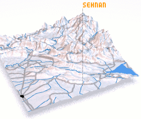 Places with similar names to Sēhnān, Iraq ::
Disclaimer :: Information on this page comes without warranty of any kind |
||
|
Where is Sēhnān? Elevation and coordinates ::
Latitude (lat): 36°9'0"N Longitude (lon): 44°33'0"E
Elevation (approx.): 767m (map arrows pan, magnifying glasses zoom) |
||
|
Visiting Sēhnān? Hotel/Accommodation ::
Book a hotel in Sēhnān Travel Guide ::
Buy a travel guide for Iraq rental cars ::
car rental offers GPS waypoint ::
download a GPX waypoint (PoI) of Sēhnān for your GPS receiver
|
||