|
search place name
|
||
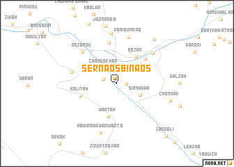
Sernaosbinaos (Arbīl, Iraq)Sernaosbinaos is a town in the Arbīl region of Iraq. An overview map of the region around Sernaosbinaos is displayed below.
regional and 3d topo map of Sernaosbinaos, Iraq ::
Sernaosbinaos airports ::
The nearest airport is TBZ - Tabriz Intl, located 218.7 km north east of Sernaosbinaos.
Other airports nearby include VAN - Van (247.8 km north west), Nearby towns ::
Serdera (1.2km east) //
Razhīkāriyān (1.9km north west) //
Chamrokhān (3.0km north west) //
Sirmāwah (3.5km south east) //
Rēzān (5.0km north east) //
Wartah (5.4km south) //
Sāyah (4.7km north east) //
Rashdūr (5.4km north east) //
Kalītah (5.0km west) //
Dār as Salām (6.7km north) //
Rezanok (6.7km north west) //
Dargalah (6.1km west) //
Guman (6.7km north east) //
Kānī Summāq (7.6km north) //
Guizan (8.1km north) //
Hawīnahāwār-i Warta (8.2km south) //
Chōmsāk (7.3km east) //
Galālah (8.6km north east) //
Zārgalī (10.5km south east) //
[all distances 'as the bird flies' and approximate] 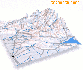 Places with similar names to Sernaosbinaos, Iraq :: Disclaimer :: Information on this page comes without warranty of any kind |
||
|
Where is Sernaosbinaos? Elevation and coordinates ::
Latitude (lat): 36°33'0"N Longitude (lon): 44°46'0"E
Elevation (approx.): 954m (map arrows pan, magnifying glasses zoom) |
||
|
Visiting Sernaosbinaos? Hotel/Accommodation ::
Book a hotel in Sernaosbinaos Travel Guide ::
Buy a travel guide for Iraq rental cars ::
car rental offers GPS waypoint ::
download a GPX waypoint (PoI) of Sernaosbinaos for your GPS receiver
|
||