|
search place name
|
||
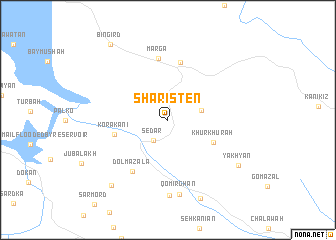
Sharisten (As Sulaymānīyah, Iraq)Sharisten is a town in the As Sulaymānīyah region of Iraq. An overview map of the region around Sharisten is displayed below.
regional and 3d topo map of Sharisten, Iraq ::
Sharisten airports ::
The nearest airport is SDG - Sanandaj, located 191.3 km south east of Sharisten.
Nearby towns ::
Sēdar (2.6km south west) //
Hawārah Barzah (3.2km east) //
Khūr Khūrah (4.8km south east) //
Kōrakānī (5.1km west) //
Halūna (6.5km north) //
Marga (6.9km north) //
Dolmazala (6.6km south west) //
Qomirghān (8.3km south) //
Qara Angö (8.4km south) //
Yākhyān (8.2km south east) //
Mawlān (9.3km south) //
Qadam Pasha (8.9km south west) //
Bingird (9.9km north west) //
[all distances 'as the bird flies' and approximate] 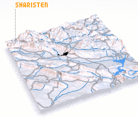 Places with similar names to Sharisten, Iraq ::
// Chūristāna (IQ)
// Chiroiu Satu Nou (RO)
// Shāristayn (IQ)
// Cherāghestān (IR)
// Cherrystone (US)
// Shahrestān (IR)
// Shahrestān (IR)
// Shahrestān (IR)
// Shahrestān (IR)
// Shahrestān (IR)
Disclaimer :: Information on this page comes without warranty of any kind |
||
|
Where is Sharisten? Elevation and coordinates ::
Latitude (lat): 35°59'28"N Longitude (lon): 45°6'17"E
Elevation (approx.): 814m (map arrows pan, magnifying glasses zoom) |
||
|
Visiting Sharisten? Hotel/Accommodation ::
Book a hotel in Sharisten Travel Guide ::
Buy a travel guide for Iraq rental cars ::
car rental offers GPS waypoint ::
download a GPX waypoint (PoI) of Sharisten for your GPS receiver
|
||