|
search place name
|
||
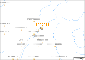
Bandabe (Mahajanga, Madagascar)Bandabe is a town in the Mahajanga region of Madagascar. An overview map of the region around Bandabe is displayed below.
regional and 3d topo map of Bandabe, Madagascar ::
Bandabe airports ::
The nearest airport is WMN - Maroantsetra, located 67.3 km east of Bandabe.
Other airports nearby include WMR - Mananara Avaratra (104.2 km south east), ZWA - Andapa (112.7 km north east), WAI - Antsohihy Ambalabe (134.0 km north west), ANM - Antalaha Antsirabato (146.3 km north east), Nearby towns ::
Antanambao (1.8km west) //
Ambodibonara (4.1km south west) //
Ambodimadiro (4.0km south west) //
Ambilombe (4.0km south west) //
Antsandrahana (5.1km north west) //
Ambodiadabo (5.6km south) //
Ampombihely (7.6km south) //
Ambalavoahangy (9.1km south east) //
[all distances 'as the bird flies' and approximate]  Places with similar names to Bandabe, Madagascar ::
// Beni Atab (MA)
// Ban Ao Tu (1) (TH)
// Ban Du (1) (TH)
// Ban Not (1) (TH)
// Ban Taba (TH)
// Ban Tabo (TH)
// Ban To I Bo (TH)
// Bandabe (MG)
// Bandabe (MG)
// Bon-e Dāb (IR)
Disclaimer :: Information on this page comes without warranty of any kind |
||
|
Where is Bandabe? Elevation and coordinates ::
Latitude (lat): 15°31'0"S Longitude (lon): 49°4'0"E
Elevation (approx.): 1018m (map arrows pan, magnifying glasses zoom) |
||
|
Visiting Bandabe? Hotel/Accommodation ::
Book a hotel in Bandabe Travel Guide ::
Buy a travel guide for Madagascar rental cars ::
car rental offers GPS waypoint ::
download a GPX waypoint (PoI) of Bandabe for your GPS receiver
|
||