|
search place name
|
||
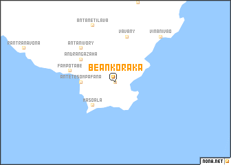
Beankoraka (Antsiranana, Madagascar)Beankoraka is a town in the Antsiranana region of Madagascar. An overview map of the region around Beankoraka is displayed below.
regional and 3d topo map of Beankoraka, Madagascar ::
Beankoraka airports ::
The nearest airport is WMR - Mananara Avaratra, located 51.4 km south west of Beankoraka.
Other airports nearby include WMN - Maroantsetra (79.0 km north west), ANM - Antalaha Antsirabato (106.0 km north), SMS - Sainte Marie (133.1 km south), ZWA - Andapa (156.6 km north west), Nearby towns ::
Ambodikily (0.0km north) //
Ambatoharana (4.0km north east) //
Masoala (5.1km south west) //
Antetesompafana (5.3km west) //
Ambavazakana (5.3km west) //
Andrangazaha (6.5km north west) //
Vavany (7.6km north) //
Fampotabe (7.4km west) //
Antanivory (7.7km north west) //
Vinanivao (10.3km north east) //
[all distances 'as the bird flies' and approximate]  Places with similar names to Beankoraka, Madagascar ::
// Bang Rak (TH)
// Ban Karako (TH)
// Ban Kraek (TH)
// Ban Krok Kaeo (TH)
// Boni-Korokou (BJ)
// Béongourgou (BF)
// Bankoroko (GN)
// Ban Karak (LA)
// Buôn Krăk (VN)
// Buôn Krôa (2) (VN)
Disclaimer :: Information on this page comes without warranty of any kind |
||
|
Where is Beankoraka? Elevation and coordinates ::
Latitude (lat): 15°57'0"S Longitude (lon): 50°12'0"E
Elevation (approx.): 25m (map arrows pan, magnifying glasses zoom) |
||
|
Visiting Beankoraka? Hotel/Accommodation ::
Book a hotel in Beankoraka Travel Guide ::
Buy a travel guide for Madagascar rental cars ::
car rental offers GPS waypoint ::
download a GPX waypoint (PoI) of Beankoraka for your GPS receiver
|
||