|
search place name
|
||
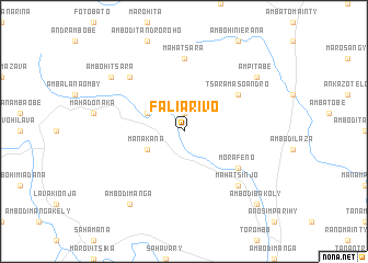
Faliarivo (Fianarantsoa, Madagascar)Faliarivo is a town in the Fianarantsoa region of Madagascar. An overview map of the region around Faliarivo is displayed below.
regional and 3d topo map of Faliarivo, Madagascar ::
Faliarivo airports ::
The nearest airport is MNJ - Mananjary, located 26.3 km south east of Faliarivo.
Other airports nearby include WFI - Fianarantsoa (115.5 km west), WVK - Manakara (117.4 km south), RVA - Farafangana (195.5 km south), Nearby towns ::
Tanambao (1.9km north) //
Manakana (3.9km south west) //
Ambia (3.9km north west) //
Morafeno (6.4km south east) //
Tsaramasoandro (6.4km north east) //
Mahatsara (7.4km north) //
Ambodiramiavona (7.6km north west) //
Mahatsinjo (7.6km south east) //
Ambodimanga (9.0km south west) //
Ambohitsara (8.9km north west) //
Ampitabe (8.9km north east) //
Ambodibakoly (10.1km south east) //
[all distances 'as the bird flies' and approximate] 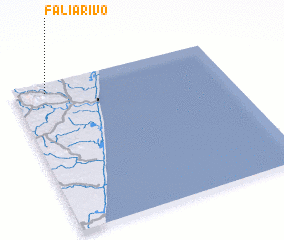 Places with similar names to Faliarivo, Madagascar ::
// Vila Ruiva (PT)
// Vila Ruiva (PT)
// Vila Ruiva (PT)
// Valerava (LT)
// Faliarivo (MG)
// Faliarivo (MG)
// Faliarivo (MG)
// Faliarivo (MG)
// Faliarivo (MG)
// Volarivo (MG)
Disclaimer :: Information on this page comes without warranty of any kind |
||
|
Where is Faliarivo? Elevation and coordinates ::
Latitude (lat): 21°4'0"S Longitude (lon): 48°9'0"E
Elevation (approx.): 110m (map arrows pan, magnifying glasses zoom) |
||
|
Visiting Faliarivo? Hotel/Accommodation ::
Book a hotel in Faliarivo Travel Guide ::
Buy a travel guide for Madagascar rental cars ::
car rental offers GPS waypoint ::
download a GPX waypoint (PoI) of Faliarivo for your GPS receiver
|
||