|
search place name
|
||
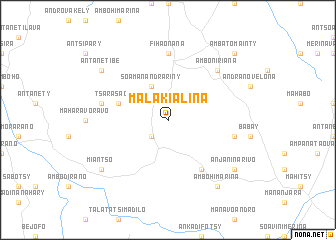
Malakialina (Antananarivo, Madagascar)Malakialina is a town in the Antananarivo region of Madagascar. An overview map of the region around Malakialina is displayed below.
regional and 3d topo map of Malakialina, Madagascar ::
Malakialina airports ::
The nearest airport is TNR - Antananarivo Ivato, located 32.7 km south east of Malakialina.
Other airports nearby include ZVA - Miandrivazo (209.1 km south west), Nearby towns ::
Soavina (2.6km south west) //
Soamanandrariny (4.1km north west) //
Tsarasaotra (5.6km west) //
Ampanokely (6.6km south east) //
Fihaonana (7.4km north) //
Ambohiboahangy (7.3km east) //
Talata-Antsindretra (7.3km west) //
Amboniriana (7.7km north east) //
Ambohimarina (9.1km south east) //
Anjaninarivo (9.0km south east) //
Miantso (9.0km south west) //
Antanetibe (9.0km north west) //
Ambatomainty (10.2km north east) //
[all distances 'as the bird flies' and approximate] 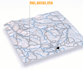 Places with similar names to Malakialina, Madagascar ::
// Mill Glen (US)
// Mill Glen (US)
// Malga Leno (IT)
// Mała Klonia (PL)
// Mala Kulina (BA)
// Mālkalni (LV)
// Malyy Klin (UA)
// Malyye Kliny (RU)
// Malyy Klin (RU)
// Malakialina (MG)
Disclaimer :: Information on this page comes without warranty of any kind |
||
|
Where is Malakialina? Elevation and coordinates ::
Latitude (lat): 18°40'0"S Longitude (lon): 47°12'0"E
Elevation (approx.): 1288m (map arrows pan, magnifying glasses zoom) |
||
|
Visiting Malakialina? Hotel/Accommodation ::
Book a hotel in Malakialina Travel Guide ::
Buy a travel guide for Madagascar rental cars ::
car rental offers GPS waypoint ::
download a GPX waypoint (PoI) of Malakialina for your GPS receiver
|
||