|
search place name
|
||
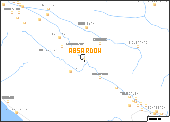
Āb Sardow (Ostān-e Būshehr, Iran)Āb Sardow is a town in the Ostān-e Būshehr region of Iran. An overview map of the region around Āb Sardow is displayed below.
regional and 3d topo map of Āb Sardow, Iran ::
Āb Sardow airports ::
The nearest airport is BUZ - Bushehr, located 173.8 km north west of Āb Sardow.
Other airports nearby include SYZ - Shiraz Shahid Dastghaib Intl (181.6 km north), KIH - Kish Island (236.1 km south east), BAH - Bahrain Intl (241.0 km south west), Nearby towns ::
Shahr-e Khāş (0.4km north east) //
Gandomzār (3.4km north west) //
Kūhcher (3.6km south west) //
Āb Garmak (4.7km south east) //
Charmūk (4.8km north east) //
Dowtūvalī (5.4km north west) //
Tāk-e Pūk (5.7km south east) //
Jamālābād (6.7km north west) //
Ḩasanābād (6.7km north west) //
Bārīkān (6.7km south east) //
Ḩarmeyak (7.3km north) //
Tang-e Mān (7.1km north west) //
Banā-ye Hādī (7.1km west) //
Cham Cheshmeh (8.7km south east) //
Ḩoseynābād (9.7km south east) //
[all distances 'as the bird flies' and approximate] 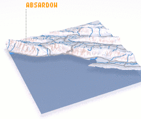 Places with similar names to Āb Sardow, Iran ::
Disclaimer :: Information on this page comes without warranty of any kind |
||
|
Where is Āb Sardow? Elevation and coordinates ::
Latitude (lat): 27°56'17"N Longitude (lon): 52°11'41"E
Elevation (approx.): 493m (map arrows pan, magnifying glasses zoom) |
||
|
Visiting Āb Sardow? Hotel/Accommodation ::
Book a hotel in Āb Sardow Travel Guide ::
Buy a travel guide for Iran rental cars ::
car rental offers GPS waypoint ::
download a GPX waypoint (PoI) of Āb Sardow for your GPS receiver
|
||