|
search place name
|
||
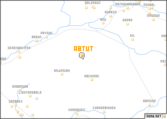
Āb Tūt (Ostān-e Kohgīlūyeh va Būyer Aḩmad, Iran)Āb Tūt is a town in the Ostān-e Kohgīlūyeh va Būyer Aḩmad region of Iran. An overview map of the region around Āb Tūt is displayed below.
regional and 3d topo map of Āb Tūt, Iran ::
Āb Tūt airports ::
The nearest airport is MRX - Bandar Mahshahr Mahshahr, located 144.9 km west of Āb Tūt.
Other airports nearby include BUZ - Bushehr (176.4 km south), AWZ - Ahwaz (202.4 km north west), QMJ - Masjed Soleiman Shahid Asyaee (210.3 km north west), SYZ - Shiraz Shahid Dastghaib Intl (216.0 km south east), Nearby towns ::
Āb Chīrak (4.9km south) //
Anjīr Sīāh (5.3km south west) //
Ārū (9.0km north east) //
Pāydūk (8.7km north west) //
[all distances 'as the bird flies' and approximate] 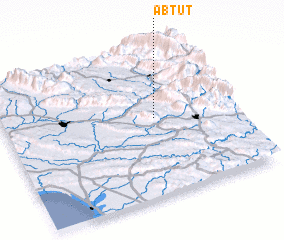 Places with similar names to Āb Tūt, Iran ::
// Abetito (IT)
// Abdet (ES)
// Āb Bād-e Do (IR)
// Abdata (TD)
// Abā ad Dūd (SA)
// Abdida (UZ)
// Abdou Dao (SN)
// Abdītā (SY)
// Abatete (NG)
// Abdata (MZ)
Disclaimer :: Information on this page comes without warranty of any kind |
||
|
Where is Āb Tūt? Elevation and coordinates ::
Latitude (lat): 30°31'45"N Longitude (lon): 50°39'40"E
Elevation (approx.): 801m (map arrows pan, magnifying glasses zoom) |
||
|
Visiting Āb Tūt? Hotel/Accommodation ::
Book a hotel in Āb Tūt Travel Guide ::
Buy a travel guide for Iran rental cars ::
car rental offers GPS waypoint ::
download a GPX waypoint (PoI) of Āb Tūt for your GPS receiver
|
||