|
search place name
|
||
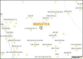
Ādeshteh (Iran)Ādeshteh is a town in Iran. An overview map of the region around Ādeshteh is displayed below.
regional and 3d topo map of Ādeshteh, Iran ::
Ādeshteh airports ::
The nearest airport is THR - Teheran Mehrabad Intl, located 234.0 km north east of Ādeshteh.
Nearby towns ::
Mashhad Mīqān (3.5km north) //
Bolbol (3.5km north) //
Eyvand-e ‘Olyā (3.9km west) //
Derman (4.7km north) //
Hazāveh (5.6km south east) //
Kīshān (6.3km south) //
Mazra‘eh-ye Kīshān (6.3km south) //
Dāyen (5.7km east) //
Khārpahlū (6.5km north east) //
Sūzān (6.6km north west) //
Shamsābād (8.0km south) //
Kūreh Dar (8.1km south) //
Now Deh (7.6km north west) //
Mashhad-e Garmeh (8.9km north east) //
Robāţ (9.3km south east) //
‘Askarābād (9.0km south east) //
[all distances 'as the bird flies' and approximate]  Places with similar names to Ādeshteh, Iran ::
// Atcheut (UA)
// Adecheda (GH)
// Atsiati (GH)
// Ad Dasht (KW)
// Atyshadu (GE)
// Aoudacht (MA)
// Atishadu (GE)
// Aadchît (LB)
// Aït Tachaout (MA)
// Ad Dechita (ER)
Disclaimer :: Information on this page comes without warranty of any kind |
||
|
Where is Ādeshteh? Elevation and coordinates ::
Latitude (lat): 34°13'9"N Longitude (lon): 49°28'34"E
Elevation (approx.): 2328m (map arrows pan, magnifying glasses zoom) |
||
|
Visiting Ādeshteh? Hotel/Accommodation ::
Book a hotel in Ādeshteh Travel Guide ::
Buy a travel guide for Iran rental cars ::
car rental offers GPS waypoint ::
download a GPX waypoint (PoI) of Ādeshteh for your GPS receiver
|
||