|
search place name
|
||
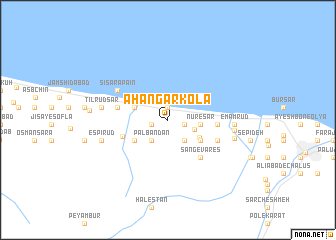
Āhangar Kolā (Iran)Āhangar Kolā is a town in Iran. An overview map of the region around Āhangar Kolā is displayed below.
regional and 3d topo map of Āhangar Kolā, Iran ::
Āhangar Kolā airports ::
The nearest airport is RZR - Ramsar, located 59.3 km north west of Āhangar Kolā.
Other airports nearby include THR - Teheran Mehrabad Intl (110.8 km south), RAS - Rasht (165.3 km north west), Nearby towns ::
Kīā Deh (1.4km north) //
Kandak (1.5km east) //
Khvoshāmīān (1.6km west) //
Mīānkī (2.7km south east) //
Pālbandān (2.8km south west) //
Kelārābād (2.6km south east) //
Nūr-e Sar (3.0km east) //
Kīā Kolā (3.0km east) //
Bālā Mesedeh (3.4km south east) //
Namak Ābrūd Sar (3.3km north west) //
Mesedeh-ye Soflá (3.7km south east) //
Akbarābād (3.7km south east) //
Jīsā (3.8km south west) //
Chārez (4.5km south west) //
Delgoshā (4.5km east) //
Moḩammad Ḩoseynābād (4.5km east) //
Sang-e Vāres̄ (5.1km south east) //
Golūr-e Bālā (4.7km west) //
Chākhānī (5.0km south east) //
Sīsarā Pā'īn (5.5km north west) //
Emām Rūd (5.9km east) //
Tīl Rūdsar (6.1km west) //
Hachīrūd (6.1km east) //
Herţeh Kolā (6.3km east) //
Espī Rūd (6.4km west) //
Sāqīkelāyeh (7.1km west) //
[all distances 'as the bird flies' and approximate]  Places with similar names to Āhangar Kolā, Iran ::
// Āhangar Kolā (IR)
// Āhangar Kolā (IR)
// Āhangar Kolā (IR)
// Āhangar Kolā (IR)
// Āhangar Kolā (IR)
// Āhangar Kolā (IR)
// Āhangar Kolā (IR)
// Āhangar Kolā (IR)
// Āhingar Kili (PK)
Disclaimer :: Information on this page comes without warranty of any kind |
||
|
Where is Āhangar Kolā? Elevation and coordinates ::
Latitude (lat): 36°41'15"N Longitude (lon): 51°17'1"E
Elevation (approx.): -20m (map arrows pan, magnifying glasses zoom) |
||
|
Visiting Āhangar Kolā? Hotel/Accommodation ::
Book a hotel in Āhangar Kolā Travel Guide ::
Buy a travel guide for Iran rental cars ::
car rental offers GPS waypoint ::
download a GPX waypoint (PoI) of Āhangar Kolā for your GPS receiver
|
||