|
search place name
|
||
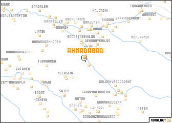
Aḩmadābād (Chahār Maḩāll va Bakhtīār, Iran)Aḩmadābād is a town in the Chahār Maḩāll va Bakhtīār region of Iran. An overview map of the region around Aḩmadābād is displayed below.
regional and 3d topo map of Aḩmadābād, Iran ::
Aḩmadābād airports ::
The nearest airport is QMJ - Masjed Soleiman Shahid Asyaee, located 155.3 km north west of Aḩmadābād.
Other airports nearby include MRX - Bandar Mahshahr Mahshahr (184.0 km south west), SYZ - Shiraz Shahid Dastghaib Intl (274.2 km south east), Nearby towns ::
Māmūr (1.0km south east) //
Ḩājjīābād (1.1km south east) //
Ḩoseynābād-e Sardasht (1.5km north) //
Mīlās (2.3km north) //
Eslāmābād-e Mīlās (3.5km north east) //
Chāhgāh-e Mīlās (3.7km north) //
Tol Mārān (3.7km north) //
Bāgh Anār-e Mīlās (3.9km north) //
Kalgeh Mīlās (4.1km north) //
Chāl Khazīneh (4.2km south west) //
Deh Now-ye Mīlās (4.3km north east) //
Bar Aftāb-e Mīlās (4.7km north) //
Melasfīd (5.1km south west) //
Najīldān (5.2km south west) //
Shesh Bahreh ‘Olyā (6.2km north east) //
Shesh Bahreh Soflá (6.5km north) //
Pīrān (6.5km north) //
Gorāzābād (6.8km north) //
Chāl Betān (6.9km north) //
Khalīlābād (7.0km north) //
Sheydān (7.0km north) //
Nāghān-e ‘Olyā (7.6km north) //
Qal‘ehcheh (7.7km north) //
Dārjūneh (7.7km north) //
Gavarūn-e Dūderā' (7.8km south) //
Gūsheh (7.9km north west) //
Kalgeh-ye Sar Dasht (7.7km south east) //
Bar Āftāb-e Shīdān (8.3km north) //
Tūbahāreh (7.3km west) //
[all distances 'as the bird flies' and approximate]  Places with similar names to Aḩmadābād, Iran ::
Disclaimer :: Information on this page comes without warranty of any kind |
||
|
Where is Aḩmadābād? Elevation and coordinates ::
Latitude (lat): 31°26'59"N Longitude (lon): 50°46'32"E
Elevation (approx.): 1765m (map arrows pan, magnifying glasses zoom) |
||
|
Visiting Aḩmadābād? Hotel/Accommodation ::
Book a hotel in Aḩmadābād Travel Guide ::
Buy a travel guide for Iran rental cars ::
car rental offers GPS waypoint ::
download a GPX waypoint (PoI) of Aḩmadābād for your GPS receiver
|
||