|
search place name
|
||
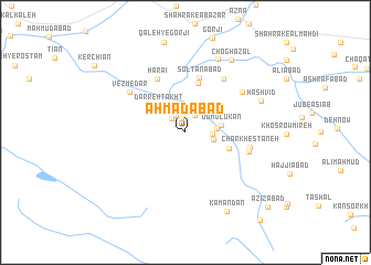
Aḩmadābād (Lorestān, Iran)Aḩmadābād is a town in the Lorestān region of Iran. An overview map of the region around Aḩmadābād is displayed below.
regional and 3d topo map of Aḩmadābād, Iran ::
Aḩmadābād airports ::
The nearest airport is QMJ - Masjed Soleiman Shahid Asyaee, located 150.2 km south of Aḩmadābād.
Nearby towns ::
Sīāvoshābād (1.5km north) //
Keneh Kūh (1.9km north east) //
Kan Kabūd (1.9km north west) //
Noşratābād (1.8km north west) //
Qashkāq (2.3km east) //
Sīveleh (2.5km east) //
Qāẕīābād (2.7km east) //
Do Molūkān (3.1km east) //
Darreh Takht (3.6km north west) //
Shengān (4.0km south east) //
Hondor (5.1km north) //
Solţānābād (5.6km north) //
Harā'ī (5.9km north west) //
Cheshmeh Solţān (6.3km north east) //
Charkhestāneh (5.7km east) //
Naşīrābād (5.8km east) //
Vezmedar (6.3km north west) //
Dowlatābād (6.3km north east) //
Borjeleh (7.9km north) //
Ḩashvīd (7.1km north east) //
Choghā Zāl (8.2km north east) //
Kamandān (8.7km south east) //
‘Azīzābād (10.3km south east) //
Shāh Pasand (10.9km south east) //
[all distances 'as the bird flies' and approximate] 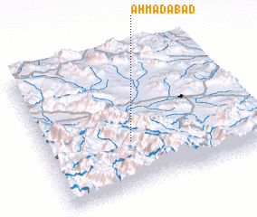 Places with similar names to Aḩmadābād, Iran ::
Disclaimer :: Information on this page comes without warranty of any kind |
||
|
Where is Aḩmadābād? Elevation and coordinates ::
Latitude (lat): 33°21'5"N Longitude (lon): 49°24'31"E
Elevation (approx.): 2014m (map arrows pan, magnifying glasses zoom) |
||
|
Visiting Aḩmadābād? Hotel/Accommodation ::
Book a hotel in Aḩmadābād Travel Guide ::
Buy a travel guide for Iran rental cars ::
car rental offers GPS waypoint ::
download a GPX waypoint (PoI) of Aḩmadābād for your GPS receiver
|
||