|
search place name
|
||
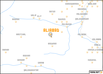
‘Alīābād (Tehrān, Iran)‘Alīābād is a town in the Tehrān region of Iran. An overview map of the region around ‘Alīābād is displayed below.
regional and 3d topo map of ‘Alīābād, Iran ::
‘Alīābād airports ::
The nearest airport is THR - Teheran Mehrabad Intl, located 65.8 km south of ‘Alīābād.
Other airports nearby include RZR - Ramsar (82.9 km north west), RAS - Rasht (181.1 km north west), Nearby towns ::
Gījān (0.0km north) //
Angūrān (3.3km south) //
Pūlād Kūh Sar (3.5km north east) //
Chāk Bazeh (5.8km north) //
Nūkres (6.3km north east) //
Chahār Bāgh (5.8km north east) //
Pūlād Kūh (5.8km north east) //
Mecher (7.1km north east) //
Mīchar (7.1km north east) //
Daznā Kotī (7.1km north east) //
Elīt (7.5km north west) //
Nāter (8.3km north) //
Emāmzādeh Faẕl-e Fāẕel (8.7km north east) //
Dalīr (8.8km north west) //
[all distances 'as the bird flies' and approximate]  Places with similar names to ‘Alīābād, Iran ::
Disclaimer :: Information on this page comes without warranty of any kind |
||
|
Where is ‘Alīābād? Elevation and coordinates ::
Latitude (lat): 36°16'0"N Longitude (lon): 51°9'0"E
Elevation (approx.): 1777m (map arrows pan, magnifying glasses zoom) |
||
|
Visiting ‘Alīābād? Hotel/Accommodation ::
Book a hotel in ‘Alīābād Travel Guide ::
Buy a travel guide for Iran rental cars ::
car rental offers GPS waypoint ::
download a GPX waypoint (PoI) of ‘Alīābād for your GPS receiver
|
||