|
search place name
|
||
Amīr Kandī (Ostān-e Āz̄arbāyjān-e Gharbī, Iran)Amīr Kandī is a town in the Ostān-e Āz̄arbāyjān-e Gharbī region of Iran. An overview map of the region around Amīr Kandī is displayed below.
regional and 3d topo map of Amīr Kandī, Iran ::

Amīr Kandī airports ::
The nearest airport is TBZ - Tabriz Intl, located 173.7 km south west of Amīr Kandī.
Other airports nearby include RAS - Rasht (218.6 km south east), Nearby towns ::
Qānlū Bolāgh (0.8km south east) //
Īn (1.8km south east) //
Deman (4.9km north east) //
Āqbolāgh-e Gadūk (4.7km south west) //
‘Alī Shānslū'ī-ye Bālā (6.3km south) //
‘Alī Shānslū'ī-ye Pā'īn (6.3km south) //
Āgh Bolāgh Gadūk-e Pā'īn (5.4km west) //
Amīr Kandī (5.5km west) //
Seyyed Beyglū (6.5km south east) //
Sobḩānlū (7.1km south east) //
Āgh Bolāgh (6.4km north west) //
Qamchī Qayeh (7.4km south west) //
Seyyed Lar (7.0km south east) //
Āqā Beyglū (8.1km south) //
Gachī Bolāghī-ye Soflá (8.2km south) //
Choqūngonash (8.1km north) //
Qeshlāq-e Moḩammad Qolī (8.7km south) //
Tūlūn (9.0km north) //
Lankeh Daraq (9.2km north) //
Qowsheh-ye ‘Olyā (10.1km south west) //
[all distances 'as the bird flies' and approximate] 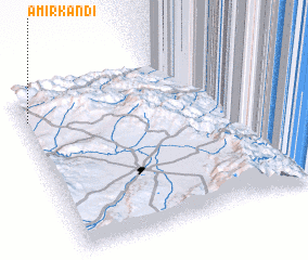 Places with similar names to Amīr Kandī, Iran ::
// Amīr Kandeh (IR)
// Amīr Kandī (IR)
Disclaimer :: Information on this page comes without warranty of any kind |
||
|
Where is Amīr Kandī? Elevation and coordinates ::
Latitude (lat): 38°50'22"N Longitude (lon): 48°0'43"E
Elevation (approx.): 1645m (map arrows pan, magnifying glasses zoom) |
||
|
Visiting Amīr Kandī? Hotel/Accommodation ::
Book a hotel in Amīr Kandī Travel Guide ::
Buy a travel guide for Iran rental cars ::
car rental offers GPS waypoint ::
download a GPX waypoint (PoI) of Amīr Kandī for your GPS receiver
|
||