|
search place name
|
||
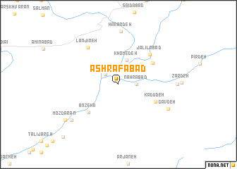
Ashrafābād (Tehrān, Iran)Ashrafābād is a town in the Tehrān region of Iran. An overview map of the region around Ashrafābād is displayed below.
regional and 3d topo map of Ashrafābād, Iran ::
Ashrafābād airports ::
The nearest airport is THR - Teheran Mehrabad Intl, located 123.6 km west of Ashrafābād.
Other airports nearby include RZR - Ramsar (228.8 km north west), Nearby towns ::
Faraḩābād (2.4km north west) //
Nahrābād (2.3km east) //
Khomedeh (4.0km north) //
Mahābād (4.3km north east) //
Ashnī (5.6km north east) //
Anzehā (5.8km south west) //
Kadū Deh (5.5km south east) //
Jalīlābād (6.3km north east) //
Lanjīneh (7.1km north west) //
Harāndeh (8.5km north) //
Gāv Deh (7.4km south east) //
Ātashān (8.2km south west) //
Mozdārān (8.9km south west) //
Deh Gardān (11.0km south west) //
[all distances 'as the bird flies' and approximate]  Places with similar names to Ashrafābād, Iran ::
// Ashrafābād (IR)
// Ashrafābād (IR)
// Ashrafābād (IR)
// Ashrafābād (IR)
// Ashrafābād (IR)
// Ashrafābād (IR)
// Ashrafābād (IR)
// Ashrafābād (IR)
// Ashrafābād (IR)
// Ashrafābād (IR)
Disclaimer :: Information on this page comes without warranty of any kind |
||
|
Where is Ashrafābād? Elevation and coordinates ::
Latitude (lat): 35°37'50"N Longitude (lon): 52°40'37"E
Elevation (approx.): 2066m (map arrows pan, magnifying glasses zoom) |
||
|
Visiting Ashrafābād? Hotel/Accommodation ::
Book a hotel in Ashrafābād Travel Guide ::
Buy a travel guide for Iran rental cars ::
car rental offers GPS waypoint ::
download a GPX waypoint (PoI) of Ashrafābād for your GPS receiver
|
||