|
search place name
|
||
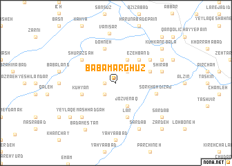
Bābā Marghūz (Iran)Bābā Marghūz is a town in Iran. An overview map of the region around Bābā Marghūz is displayed below.
regional and 3d topo map of Bābā Marghūz, Iran ::
Bābā Marghūz airports ::
The nearest airport is RAS - Rasht, located 85.5 km north east of Bābā Marghūz.
Other airports nearby include RZR - Ramsar (160.5 km east), SDG - Sanandaj (242.7 km south west), Nearby towns ::
Zashkān (1.5km west) //
Zājkān (1.5km west) //
Z̄akān (2.4km south west) //
Rezehband (2.4km north east) //
Zerehband (4.0km north) //
Jozvenaq (4.0km south) //
Ezeh Band (4.7km north east) //
Dohneh (5.8km north) //
Qāẕī Bolāgh (4.8km north east) //
Lār (5.8km south) //
Kūhyān (4.8km south west) //
Shūrazgāh (5.8km north west) //
Mūrestāneh (5.8km north east) //
Sorkheh Dīzaj (5.5km east) //
Shīrāb (6.2km east) //
Yeylāq-e Mashhadgāh (7.1km south west) //
Vanīsar (8.1km north) //
Dastjerdeh (7.0km north east) //
Sardāb (8.0km south) //
Bādāmestān (8.6km south west) //
Chāl (8.1km south west) //
Sardāb (8.1km south east) //
Kūh Kan-e Bālā (8.1km north east) //
Kūh-e Kan (9.5km north east) //
Kūh Kan-e Pā'īn (9.5km north east) //
Shendestān (9.5km south east) //
Zardeh (9.5km south east) //
[all distances 'as the bird flies' and approximate]  Places with similar names to Bābā Marghūz, Iran :: Disclaimer :: Information on this page comes without warranty of any kind |
||
|
Where is Bābā Marghūz? Elevation and coordinates ::
Latitude (lat): 36°49'0"N Longitude (lon): 48°53'0"E
Elevation (approx.): 1291m (map arrows pan, magnifying glasses zoom) |
||
|
Visiting Bābā Marghūz? Hotel/Accommodation ::
Book a hotel in Bābā Marghūz Travel Guide ::
Buy a travel guide for Iran rental cars ::
car rental offers GPS waypoint ::
download a GPX waypoint (PoI) of Bābā Marghūz for your GPS receiver
|
||