|
search place name
|
||
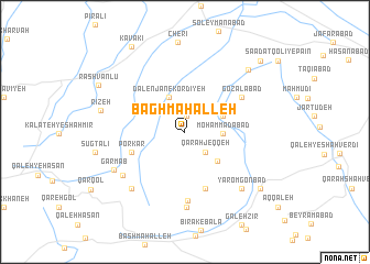
Bāgh Maḩalleh (Khorāsān, Iran)Bāgh Maḩalleh is a town in the Khorāsān region of Iran. An overview map of the region around Bāgh Maḩalleh is displayed below.
regional and 3d topo map of Bāgh Maḩalleh, Iran ::
Bāgh Maḩalleh airports ::
The nearest airport is ASB - Ashkhabad Ashgabat, located 101.6 km north of Bāgh Maḩalleh.
Nearby towns ::
Dālenjān-e Torkīyeh (1.7km north) //
Qarah Jeqqeh (2.6km south east) //
Moḩammadābād (3.1km east) //
Dālenjān-e Kordīyeh (3.8km north) //
Azdak (3.5km north east) //
Pīreh (3.9km south east) //
Zādak (4.4km north east) //
Porkār (4.7km south west) //
Gūgdarreh (6.0km south) //
Gozalābād (5.8km north east) //
Janjālābād (7.0km south) //
Qareh Cheshmeh (7.6km south) //
Mardkānlū (6.7km south west) //
Zeynekānlū (7.2km south west) //
Yārom Gonbad (7.4km south east) //
Garmāb (7.0km south west) //
Rīzeh (7.2km west) //
Dāghīān (8.1km north east) //
Shīrghān (8.4km south east) //
Rashvānlū (8.4km north west) //
Kavākī (9.7km north west) //
‘Asgarābād (9.4km north east) //
[all distances 'as the bird flies' and approximate]  Places with similar names to Bāgh Maḩalleh, Iran ::
// Buffum Hill (US)
Disclaimer :: Information on this page comes without warranty of any kind |
||
|
Where is Bāgh Maḩalleh? Elevation and coordinates ::
Latitude (lat): 37°5'6"N Longitude (lon): 58°9'54"E
Elevation (approx.): 1599m (map arrows pan, magnifying glasses zoom) |
||
|
Visiting Bāgh Maḩalleh? Hotel/Accommodation ::
Book a hotel in Bāgh Maḩalleh Travel Guide ::
Buy a travel guide for Iran rental cars ::
car rental offers GPS waypoint ::
download a GPX waypoint (PoI) of Bāgh Maḩalleh for your GPS receiver
|
||