|
search place name
|
||
Bahārestān (Khorāsān, Iran)Bahārestān is a town in the Khorāsān region of Iran. An overview map of the region around Bahārestān is displayed below.
regional and 3d topo map of Bahārestān, Iran ::
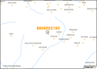
Nearby towns ::
Zhāleh (2.3km south east) //
Sanā'ī (3.3km east) //
Golsarā (6.1km south) //
‘Anbar Sarā (5.5km south east) //
Kalāteh-ye Sorkhī (6.5km south west) //
Pā Qal‘eh (7.1km east) //
Soleymānī (8.7km north) //
Qāsempūr (10.8km north east) //
[all distances 'as the bird flies' and approximate] 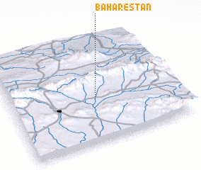 Places with similar names to Bahārestān, Iran ::
// Bahārestān (IR)
// Bahārestān (IR)
// Bahārestān (IR)
// Bahārestān (IR)
// Bahārestān (IR)
// Bahārestān (IR)
// Bahārestān (IR)
// Bahārestān (IR)
// Bahārestān (IR)
// Bahārestān (AF)
Disclaimer :: Information on this page comes without warranty of any kind |
||
|
Where is Bahārestān? Elevation and coordinates ::
Latitude (lat): 35°25'32"N Longitude (lon): 59°31'15"E
Elevation (approx.): 1743m (map arrows pan, magnifying glasses zoom) |
||
|
Visiting Bahārestān? Hotel/Accommodation ::
Book a hotel in Bahārestān Travel Guide ::
Buy a travel guide for Iran rental cars ::
car rental offers GPS waypoint ::
download a GPX waypoint (PoI) of Bahārestān for your GPS receiver
|
||