|
search place name
|
||
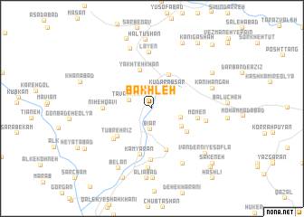
Bākhleh (Kordestān, Iran)Bākhleh is a town in the Kordestān region of Iran. An overview map of the region around Bākhleh is displayed below.
regional and 3d topo map of Bākhleh, Iran ::
Bākhleh airports ::
The nearest airport is SDG - Sanandaj, located 44.9 km north of Bākhleh.
Other airports nearby include KSH - Bakhtaran Shahid Ashrafi Esfahani (58.5 km south), Nearby towns ::
Bīār (2.6km south) //
Būāneh (2.7km north) //
Tavānkesh (2.6km north west) //
Kūdarābsar (3.0km north east) //
A‘zamābād (3.2km east) //
Yaghvāsī (3.7km south east) //
Morvārīd (4.5km north) //
Yakhteh Khān (4.9km north) //
Gorg-e Ābī (4.6km south east) //
Shīrvāneh (5.3km south) //
Tūbreh Rīz (4.9km south west) //
Mo'men (4.8km east) //
Kāmyārān (5.9km south) //
Nīḩeh Qavī (4.9km west) //
Āhangarān (5.4km south west) //
Zarrīn Jūb (6.4km south) //
Māman (5.7km east) //
Lāyen (6.9km north) //
Khānomābād (7.4km south) //
Ḩājjī Shūreh (7.4km south east) //
Kanī Leylī (7.6km north) //
Kānī Hangah (6.6km east) //
Belān (8.1km south west) //
Haltūshān (8.5km north) //
Jahād-e Sāzandegī (8.6km south) //
Vandernī-ye Soflá (7.8km south east) //
‘Alīābād (8.6km south) //
Kāz̧emābād (7.5km north east) //
Dakal-e Haltūshān (8.6km north) //
[all distances 'as the bird flies' and approximate]  Places with similar names to Bākhleh, Iran ::
Disclaimer :: Information on this page comes without warranty of any kind |
||
|
Where is Bākhleh? Elevation and coordinates ::
Latitude (lat): 34°50'39"N Longitude (lon): 46°56'57"E
Elevation (approx.): 1602m (map arrows pan, magnifying glasses zoom) |
||
|
Visiting Bākhleh? Hotel/Accommodation ::
Book a hotel in Bākhleh Travel Guide ::
Buy a travel guide for Iran rental cars ::
car rental offers GPS waypoint ::
download a GPX waypoint (PoI) of Bākhleh for your GPS receiver
|
||