|
search place name
|
||
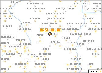
Bāshkalān (Iran)Bāshkalān is a town in Iran. An overview map of the region around Bāshkalān is displayed below.
regional and 3d topo map of Bāshkalān, Iran ::
Bāshkalān airports ::
The nearest airport is TBZ - Tabriz Intl, located 148.4 km south west of Bāshkalān.
Nearby towns ::
Īllī (1.3km east) //
Qameshlū (3.2km south east) //
Aznāb-e ‘Olyā (3.6km south) //
Qeshlāq-e Hārnā (3.8km north) //
Zīādlū (3.1km west) //
Qeshlāq-e Najaf-e Tarākameh (3.5km south west) //
Chanāq (4.1km south west) //
Aznāb-e Khāleşeh (4.5km south east) //
Qeshlāq-e Dārchīn (4.7km north east) //
Mardlū (4.5km east) //
Zargar (5.7km south) //
Qeshlāq-e Khānlū (5.8km north) //
Qānlī Qūzī (6.3km north east) //
Qarah Qayah-ye Shakarlū (5.9km east) //
Qeshlāq-e Qānlī Qūzī (5.9km east) //
Tābeslānaq (7.5km south) //
Qarah Daraq-e ‘Olyā (7.6km north) //
Ūzūn Qayah (7.2km north west) //
Qāţār (6.8km north east) //
Shekarlū (7.0km south east) //
Chāreq Dāsh (7.8km south east) //
Āq Berāz (9.0km south west) //
Vīrāvjen (8.1km south west) //
Qūytūl (7.9km south west) //
Qūshchī Bāyrām Khvājeh (8.3km south west) //
Qayah Dībī (9.3km south west) //
[all distances 'as the bird flies' and approximate]  Places with similar names to Bāshkalān, Iran ::
// Bāshākalān (IQ)
// Beach Glen (US)
// Beech Glen (US)
// Beech Glen (US)
// Bichha Kalān (PK)
// Bucha Kalān (PK)
// Beech Glen (US)
Disclaimer :: Information on this page comes without warranty of any kind |
||
|
Where is Bāshkalān? Elevation and coordinates ::
Latitude (lat): 39°4'57"N Longitude (lon): 47°26'7"E
Elevation (approx.): 698m (map arrows pan, magnifying glasses zoom) |
||
|
Visiting Bāshkalān? Hotel/Accommodation ::
Book a hotel in Bāshkalān Travel Guide ::
Buy a travel guide for Iran rental cars ::
car rental offers GPS waypoint ::
download a GPX waypoint (PoI) of Bāshkalān for your GPS receiver
|
||