|
search place name
|
||
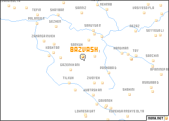
Bazvash (Kordestān, Iran)Bazvash is a town in the Kordestān region of Iran. An overview map of the region around Bazvash is displayed below.
regional and 3d topo map of Bazvash, Iran ::
Bazvash airports ::
The nearest airport is SDG - Sanandaj, located 39.8 km north east of Bazvash.
Other airports nearby include KSH - Bakhtaran Shahid Ashrafi Esfahani (83.5 km south east), Nearby towns ::
Gelyān (2.1km north east) //
Sar Kūh (2.7km north west) //
Gāzer Khānī (3.3km south west) //
Mīrgasār (3.7km north east) //
Sīvyah (4.5km north) //
Fīrūzābād (4.3km west) //
Zīvoyeh (5.3km south) //
Tīlkūh (5.7km south west) //
Pāshābād (5.2km south east) //
Pīr Bāgh (6.2km north) //
Rīv (6.0km south east) //
Anārleh (6.2km north east) //
Mīsūrāb (6.8km south) //
Samūydar (6.8km north) //
Kāshtar (5.9km west) //
Yūzī Dar (6.6km north west) //
Jūb Tāshān (7.8km south) //
Tangīvar (6.6km west) //
Handīman (7.0km east) //
Dezhen (9.2km north west) //
[all distances 'as the bird flies' and approximate] 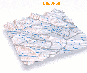 Places with similar names to Bazvash, Iran :: Disclaimer :: Information on this page comes without warranty of any kind |
||
|
Where is Bazvash? Elevation and coordinates ::
Latitude (lat): 34°59'41"N Longitude (lon): 46°41'50"E
Elevation (approx.): 1614m (map arrows pan, magnifying glasses zoom) |
||
|
Visiting Bazvash? Hotel/Accommodation ::
Book a hotel in Bazvash Travel Guide ::
Buy a travel guide for Iran rental cars ::
car rental offers GPS waypoint ::
download a GPX waypoint (PoI) of Bazvash for your GPS receiver
|
||