|
search place name
|
||
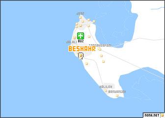
Beshahr (Ostān-e Būshehr, Iran)Beshahr is a town in the Ostān-e Būshehr region of Iran. An overview map of the region around Beshahr is displayed below.
regional and 3d topo map of Beshahr, Iran ::
Beshahr airports ::
The nearest airport is BUZ - Bushehr, located 5.1 km north of Beshahr.
Other airports nearby include SYZ - Shiraz Shahid Dastghaib Intl (184.6 km north east), MRX - Bandar Mahshahr Mahshahr (245.7 km north west), Nearby towns ::
Khasham-e Khvājeh (0.5km west) //
Dastak (0.5km west) //
Ravānī (1.3km south east) //
Bahmanī (1.7km north west) //
Mokh Boland (2.1km north) //
Dabbas (2.9km north west) //
Jalālī (3.7km north west) //
Davās (4.0km north) //
Tangak-e Moḩammad Ja‘farī (3.9km east) //
Makh Boland (4.1km north east) //
Tangak-e -afarī (4.1km north east) //
Tang-e Zanganeh (4.2km east) //
Bāgh-e Mollā (5.0km north) //
Moqkeh (5.2km north) //
Leyl-e Baḩreynī (5.2km north) //
Jafreh-ye ‘Ellatbāsh (7.4km north) //
Bon Māneh (7.6km north) //
Bon Māneh (7.6km north) //
Salīmābād (7.6km north) //
Shekār (7.6km north) //
Sang (7.7km north) //
Jofreh-ye Mo‘īnī (8.0km north) //
Būshehr (8.5km north) //
Pūder (8.8km north) //
Halīleh (8.5km south east) //
Bandargāh (10.8km south east) //
[all distances 'as the bird flies' and approximate]  Places with similar names to Beshahr, Iran ::
Disclaimer :: Information on this page comes without warranty of any kind |
||
|
Where is Beshahr? Elevation and coordinates ::
Latitude (lat): 28°53'55"N Longitude (lon): 50°50'16"E
Elevation (approx.): 27m (map arrows pan, magnifying glasses zoom) |
||
|
Visiting Beshahr? Hotel/Accommodation ::
Book a hotel in Beshahr Travel Guide ::
Buy a travel guide for Iran rental cars ::
car rental offers GPS waypoint ::
download a GPX waypoint (PoI) of Beshahr for your GPS receiver
|
||