|
search place name
|
||
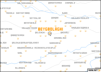
Beyg Bolāghī (Ostān-e Āz̄arbāyjān-e Sharqī, Iran)Beyg Bolāghī is a town in the Ostān-e Āz̄arbāyjān-e Sharqī region of Iran. An overview map of the region around Beyg Bolāghī is displayed below.
regional and 3d topo map of Beyg Bolāghī, Iran ::
Beyg Bolāghī airports ::
The nearest airport is TBZ - Tabriz Intl, located 133.4 km north west of Beyg Bolāghī.
Nearby towns ::
Qahremānlū (1.5km west) //
Qelīch Chī (2.9km west) //
Dāsh Bolāgh (3.5km south east) //
Qarehjeh Qīā (4.0km north) //
Sham‘ī Kandī (4.0km south) //
Qāẕī Valī (4.4km east) //
Qal‘eh Jūq-e Alflū (5.6km south) //
Qomqān (5.8km north) //
Gavanlū (5.8km north) //
Reẕā Khānlū-ye Soflá (5.8km south) //
Tāzeh Kand Reẕā Khānlū (5.8km south) //
Pūrsekhlū (6.3km north east) //
Bayāt-e Soflá (6.3km north west) //
Āghcheh Darband (5.8km north east) //
Kolūjeh-ye Ghamī (6.2km west) //
Shīr Shīr Dāghī (7.6km south) //
Īstgāh-e Sheykh Şafī (7.6km south) //
Seyyedlar (7.1km north west) //
Ja‘farābād (7.0km north east) //
Bayāt-e Bālā (7.0km north west) //
‘Ajamī (8.6km north east) //
Dūzanān (8.6km south east) //
[all distances 'as the bird flies' and approximate]  Places with similar names to Beyg Bolāghī, Iran ::
// Bikbulovo (RU)
// Beyg Bolāghī (IR)
Disclaimer :: Information on this page comes without warranty of any kind |
||
|
Where is Beyg Bolāghī? Elevation and coordinates ::
Latitude (lat): 37°25'0"N Longitude (lon): 47°27'0"E
Elevation (approx.): 1704m (map arrows pan, magnifying glasses zoom) |
||
|
Visiting Beyg Bolāghī? Hotel/Accommodation ::
Book a hotel in Beyg Bolāghī Travel Guide ::
Buy a travel guide for Iran rental cars ::
car rental offers GPS waypoint ::
download a GPX waypoint (PoI) of Beyg Bolāghī for your GPS receiver
|
||