|
search place name
|
||
Beyt-e Sa‘īd (Khūzestān, Iran)Beyt-e Sa‘īd is a town in the Khūzestān region of Iran. An overview map of the region around Beyt-e Sa‘īd is displayed below.
regional and 3d topo map of Beyt-e Sa‘īd, Iran ::

Beyt-e Sa‘īd airports ::
The nearest airport is AWZ - Ahwaz, located 28.2 km south east of Beyt-e Sa‘īd.
Other airports nearby include QMJ - Masjed Soleiman Shahid Asyaee (77.3 km north east), MRX - Bandar Mahshahr Mahshahr (122.5 km south east), ABD - Abadan (138.1 km south), BSR - Basrah Intl (146.0 km south west), Nearby towns ::
Gazkār (0.4km north west) //
Borvāyeh-ye Toreyjī (1.3km north) //
Gezgāzeh (1.6km west) //
Qāţe‘ (1.6km west) //
Beyt-e Moqāţţaf (1.9km south) //
Borvāyeh-ye ‘Azīz (2.5km north west) //
Moḩammad-e Chalībeh (2.4km south east) //
Kamp-e Albājī (3.2km south west) //
Seyyed (3.2km east) //
Marā‘ūneh (4.0km north west) //
Mobeyţīḩeh-ye Seh (4.0km east) //
Mobeyţīḩeh-ye Yek (4.7km south east) //
Ḩalāf-e Do (5.6km south) //
Chepseh-ye Kūchek (5.1km south west) //
Mobeyţīḩeh-ye Do (5.4km south east) //
Om Ogleh (5.6km north east) //
Ālbājī (6.0km south) //
Marāveneh (6.2km north) //
Dowb-e Jerdān (6.0km south east) //
Barvāyeh (6.0km north west) //
Borvāyeh-ye ‘Omeyr (6.7km north west) //
Ālbū Sanvān (6.3km north west) //
Qarbīyeh (6.4km north west) //
Chepseh-ye Bozorg (6.4km west) //
Īstgāh-e Āhūdasht (6.4km west) //
Mobeyţīḩeh (6.6km east) //
Mobeyţīḩeh-ye Chahār (6.6km east) //
Qarbīyeh (7.1km west) //
Khāvar (7.7km north east) //
[all distances 'as the bird flies' and approximate] 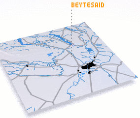 Places with similar names to Beyt-e Sa‘īd, Iran ::
// Bautista (PH)
// Bautista (PH)
// Bautista (PH)
// Bautista (PH)
// Bautista (PH)
// Butte City (US)
// Butte City (US)
// Båtstø (NO)
// Biedźiadów (PL)
// Batista (CU)
Disclaimer :: Information on this page comes without warranty of any kind |
||
|
Where is Beyt-e Sa‘īd? Elevation and coordinates ::
Latitude (lat): 31°34'0"N Longitude (lon): 48°38'0"E
Elevation (approx.): 27m (map arrows pan, magnifying glasses zoom) |
||
|
Visiting Beyt-e Sa‘īd? Hotel/Accommodation ::
Book a hotel in Beyt-e Sa‘īd Travel Guide ::
Buy a travel guide for Iran rental cars ::
car rental offers GPS waypoint ::
download a GPX waypoint (PoI) of Beyt-e Sa‘īd for your GPS receiver
|
||