|
search place name
|
||
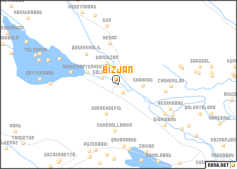
Bīzjān (Fārs, Iran)Bīzjān is a town in the Fārs region of Iran. An overview map of the region around Bīzjān is displayed below.
regional and 3d topo map of Bīzjān, Iran ::
Bīzjān airports ::
The nearest airport is SYZ - Shiraz Shahid Dastghaib Intl, located 73.2 km south of Bīzjān.
Other airports nearby include BUZ - Bushehr (210.1 km south west), AZD - Yazd Shahid Sadooghi (256.7 km north east), Nearby towns ::
Aḩmadābād (1.5km south east) //
Golījān (2.6km north west) //
Shahrak (3.3km east) //
Dorūdzan (3.8km north west) //
Darreh Sefīd (4.9km south) //
Sadd-e Dāryūsh-e Kabīr (4.7km north west) //
Ḩeşār (6.6km north) //
Qaşr-e Khalīl (6.6km north west) //
Kūh-e Mollā Amīr (7.3km south) //
Darreh Māl (6.6km east) //
Malekābād (6.8km west) //
Chāh-e Mīlak (7.2km east) //
Samāābād (7.8km south east) //
Ḩesāmābād (8.0km south east) //
Gīshīābād (9.0km south east) //
Jeshnīān (8.9km south east) //
[all distances 'as the bird flies' and approximate]  Places with similar names to Bīzjān, Iran ::
// Bezujno (BA)
// Busygino (RU)
// Bozījān (IR)
// Būsjīn (IR)
// Bisigen (BF)
// Bois Jaune (HT)
// Bois Jaune (HT)
// Bois Jeanay (HT)
// Bosjean (FR)
// Bois-Jean (FR)
Disclaimer :: Information on this page comes without warranty of any kind |
||
|
Where is Bīzjān? Elevation and coordinates ::
Latitude (lat): 30°11'29"N Longitude (lon): 52°28'3"E
Elevation (approx.): 1627m (map arrows pan, magnifying glasses zoom) |
||
|
Visiting Bīzjān? Hotel/Accommodation ::
Book a hotel in Bīzjān Travel Guide ::
Buy a travel guide for Iran rental cars ::
car rental offers GPS waypoint ::
download a GPX waypoint (PoI) of Bīzjān for your GPS receiver
|
||