|
search place name
|
||
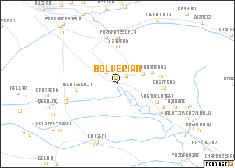
Bolverīān (Khorāsān, Iran)Bolverīān is a town in the Khorāsān region of Iran. An overview map of the region around Bolverīān is displayed below.
regional and 3d topo map of Bolverīān, Iran ::
Bolverīān airports ::
The nearest airport is ASB - Ashkhabad Ashgabat, located 111.8 km north of Bolverīān.
Nearby towns ::
Bolverīān (0.1km north) //
Ja‘farābād (1.7km north east) //
Fatḩābād (2.4km north west) //
Dāvūdlī (3.7km north east) //
Sha‘bānābād (4.8km north east) //
Dīzāvand (5.9km north) //
Āb Gorg-e Bālā (5.3km west) //
Yasāvolbāshī (5.8km south east) //
Qareh Jeqqeh (5.7km east) //
Farkhān-e Soflá (7.4km north) //
Kalāteh-ye Ḩājjī Barāt (7.4km north) //
Dūstābād (6.0km east) //
Zalābād (7.6km north) //
Kheyrābād (6.9km south east) //
Qal‘eh Dowlū (6.8km west) //
Ālmajeq (7.2km south east) //
Āb Gorg-e Pā'in (6.8km west) //
Qal‘eh-ye ‘Abbāsī (7.2km south west) //
Farkhān-e Shāhrāh (10.8km north west) //
[all distances 'as the bird flies' and approximate]  Places with similar names to Bolverīān, Iran ::
// Bella Farnia (IT)
// Belevren (BG)
// Balveren (TR)
// Balafarani (GN)
// Bolverīān (IR)
// Belverne (FR)
// Ballyvourney (IE)
// Balfron (GB)
// Ballyvirrane (IE)
// Ballyvorney (IE)
Disclaimer :: Information on this page comes without warranty of any kind |
||
|
Where is Bolverīān? Elevation and coordinates ::
Latitude (lat): 37°0'0"N Longitude (lon): 58°37'0"E
Elevation (approx.): 1324m (map arrows pan, magnifying glasses zoom) |
||
|
Visiting Bolverīān? Hotel/Accommodation ::
Book a hotel in Bolverīān Travel Guide ::
Buy a travel guide for Iran rental cars ::
car rental offers GPS waypoint ::
download a GPX waypoint (PoI) of Bolverīān for your GPS receiver
|
||