|
search place name
|
||
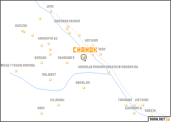
Chāhok (Sīstān va Balūchestān, Iran)Chāhok is a town in the Sīstān va Balūchestān region of Iran. An overview map of the region around Chāhok is displayed below.
regional and 3d topo map of Chāhok, Iran ::
Chāhok airports ::
The nearest airport is TRB - Turbo Turbat Intl, located 211.8 km south east of Chāhok.
Other airports nearby include ZBR - Chah Bahar (226.5 km south west), PSI - Pasni (289.1 km south east), Nearby towns ::
Kahn-e Shīr Moḩammad (2.0km north east) //
Chād-e Pā'īn (3.2km north) //
Sāndok (3.3km north east) //
Katīkan (3.6km north) //
Seh Akbar (3.7km west) //
Sīāh Ettefāq-e Pā'īn (3.7km west) //
Kahn-e Jān Moḩammad-e Shīr Moḩammad (5.1km south east) //
Chād-e Bālā (5.8km north) //
Abkalān (5.9km south) //
Chashmā (6.9km north west) //
Golmī (7.1km west) //
Naşrābād (8.0km north west) //
Kahn-e Karīm Bakhsh (7.4km west) //
Garsāmān-e Pā'īn (8.3km north west) //
Nal Bast (8.0km south west) //
Kahn-e Fīrūz (8.2km north west) //
[all distances 'as the bird flies' and approximate] 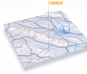 Places with similar names to Chāhok, Iran ::
Disclaimer :: Information on this page comes without warranty of any kind |
||
|
Where is Chāhok? Elevation and coordinates ::
Latitude (lat): 27°15'11"N Longitude (lon): 61°26'13"E
Elevation (approx.): 1361m (map arrows pan, magnifying glasses zoom) |
||
|
Visiting Chāhok? Hotel/Accommodation ::
Book a hotel in Chāhok Travel Guide ::
Buy a travel guide for Iran rental cars ::
car rental offers GPS waypoint ::
download a GPX waypoint (PoI) of Chāhok for your GPS receiver
|
||