|
search place name
|
||
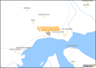
Chāh Şaḩārī (Hormozgān, Iran)Chāh Şaḩārī is a town in the Hormozgān region of Iran. An overview map of the region around Chāh Şaḩārī is displayed below.
regional and 3d topo map of Chāh Şaḩārī, Iran ::
Chāh Şaḩārī airports ::
The nearest airport is BND - Bandar Abbass Intl, located 74.1 km east of Chāh Şaḩārī.
Other airports nearby include BDH - Bandar Lengeh (98.9 km south west), KHS - Khasab (108.1 km south east), RKT - Ras Al Khaimah Intl (156.1 km south), KIH - Kish Island (176.2 km west), Nearby towns ::
Chāh Şaḩārī (0.9km south east) //
Bāqīābād (1.6km south west) //
Pol-e Gelkan (3.5km east) //
Pol-e Gel Kan (3.5km east) //
Pol-e Angūr (5.4km east) //
Pīr Ḩarīreh (5.7km east) //
Tang-e Kheyr (6.9km north) //
Mīr Ḩarīreh (6.2km east) //
Gūrī (6.9km north west) //
Pol-e Sharqī (6.7km east) //
[all distances 'as the bird flies' and approximate] 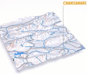 Places with similar names to Chāh Şaḩārī, Iran ::
// Chāh Şaḩārī (IR)
// Shizuhara (JP)
Disclaimer :: Information on this page comes without warranty of any kind |
||
|
Where is Chāh Şaḩārī? Elevation and coordinates ::
Latitude (lat): 27°0'5"N Longitude (lon): 55°40'14"E
Elevation (approx.): 21m (map arrows pan, magnifying glasses zoom) |
||
|
Visiting Chāh Şaḩārī? Hotel/Accommodation ::
Book a hotel in Chāh Şaḩārī Travel Guide ::
Buy a travel guide for Iran rental cars ::
car rental offers GPS waypoint ::
download a GPX waypoint (PoI) of Chāh Şaḩārī for your GPS receiver
|
||