|
search place name
|
||
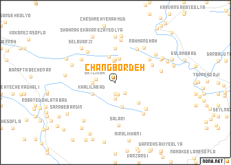
Changbordeh (Lorestān, Iran)Changbordeh is a town in the Lorestān region of Iran. An overview map of the region around Changbordeh is displayed below.
regional and 3d topo map of Changbordeh, Iran ::
Changbordeh airports ::
The nearest airport is KSH - Bakhtaran Shahid Ashrafi Esfahani, located 137.2 km north west of Changbordeh.
Other airports nearby include QMJ - Masjed Soleiman Shahid Asyaee (201.8 km south east), SDG - Sanandaj (216.8 km north west), Nearby towns ::
Cheshmeh Bīd (1.9km south) //
Qal‘eh-ye Morādī (2.0km south) //
Darreh Gorg (2.1km south east) //
Rapamleh (2.6km south) //
Seyl Mīsh (2.7km west) //
Barālīkeh (3.5km north) //
Rokh Sefīd (3.1km west) //
Seyl Mīsh-e Soflá (3.1km west) //
Sarāb-e Şandal (3.7km north) //
Z̄ahābī (3.7km north) //
Tableh (3.7km north) //
Neyleh (3.9km north) //
Qal‘eh Now (4.0km south) //
Khalīlābād (3.6km south west) //
Z̄ahābī (4.3km north) //
Posht Melah (4.5km south east) //
Posht Meleh (4.5km south east) //
Chūlān Deym (5.6km north) //
Cheshmeh Kabūd-e ‘Olyā (5.6km north) //
Darreh Qomqomeh (5.6km north) //
Chūlān-e Ābī (6.2km north east) //
Ābtāf (6.0km south east) //
Gol-e Zard (5.8km north east) //
Rīg-e Sefīd (5.9km north west) //
Dārbāshī-ye Vosţá (5.9km north east) //
Vartakhtūn (6.3km north west) //
Seyyedeh (6.4km south east) //
Aznāvaleh (6.9km north) //
Sālārī (7.0km south) //
[all distances 'as the bird flies' and approximate] 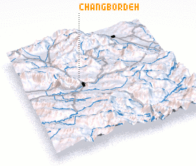 Places with similar names to Changbordeh, Iran ::
// Chan Quebrada (BZ)
Disclaimer :: Information on this page comes without warranty of any kind |
||
|
Where is Changbordeh? Elevation and coordinates ::
Latitude (lat): 33°40'0"N Longitude (lon): 48°24'0"E
Elevation (approx.): 2268m (map arrows pan, magnifying glasses zoom) |
||
|
Visiting Changbordeh? Hotel/Accommodation ::
Book a hotel in Changbordeh Travel Guide ::
Buy a travel guide for Iran rental cars ::
car rental offers GPS waypoint ::
download a GPX waypoint (PoI) of Changbordeh for your GPS receiver
|
||