|
search place name
|
||
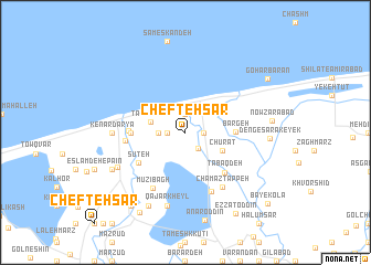
Chefteh Sar (Iran)Chefteh Sar is a town in Iran. An overview map of the region around Chefteh Sar is displayed below.
regional and 3d topo map of Chefteh Sar, Iran ::
Chefteh Sar airports ::
The nearest airport is THR - Teheran Mehrabad Intl, located 207.2 km south west of Chefteh Sar.
Nearby towns ::
Moḩammadābād (1.5km east) //
Tajan Lateh (1.9km north) //
Chīnam Dahaneh (1.5km west) //
Valūjā (1.9km south east) //
Qāsemābād (2.2km west) //
Tāzehābād (3.0km west) //
Chūrat (3.5km south east) //
Bargeh (4.1km east) //
Sharīfābād (4.5km west) //
Shīlāt-e Faraḩābād (4.5km west) //
Sūteh (4.8km south west) //
Ţabaq Deh (5.2km south east) //
Khazarābād (4.6km west) //
Faraḩābād (4.9km west) //
Dūl Marz (6.4km south) //
Dūl Marz (6.4km south) //
Mūzī Bāgh (6.3km south west) //
Chamāz Tappeh (6.3km south east) //
Kenār Daryā (5.9km west) //
Qājār Kheyl (7.6km south) //
Ḩamīdābād (6.5km south west) //
Ţāherābād (7.0km south west) //
Panbeh Chūleh-ye Pā'īn (8.0km south) //
Dengesarak-e Yek (6.8km east) //
Esfandān-e Pā'īn (7.9km south west) //
Nowz̄arābād (7.1km east) //
Anār od Dīn (9.0km south) //
Esfandān-e Bālā (8.6km south west) //
Panbeh Chūleh-ye Bālā (8.9km south west) //
[all distances 'as the bird flies' and approximate]  Places with similar names to Chefteh Sar, Iran ::
Disclaimer :: Information on this page comes without warranty of any kind |
||
|
Where is Chefteh Sar? Elevation and coordinates ::
Latitude (lat): 36°48'0"N Longitude (lon): 53°10'0"E
Elevation (approx.): -21m (map arrows pan, magnifying glasses zoom) |
||
|
Visiting Chefteh Sar? Hotel/Accommodation ::
Book a hotel in Chefteh Sar Travel Guide ::
Buy a travel guide for Iran rental cars ::
car rental offers GPS waypoint ::
download a GPX waypoint (PoI) of Chefteh Sar for your GPS receiver
|
||