|
search place name
|
||
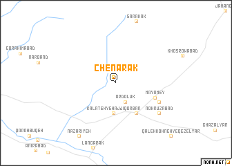
Chenārak (Khorāsān, Iran)Chenārak is a town in the Khorāsān region of Iran. An overview map of the region around Chenārak is displayed below.
regional and 3d topo map of Chenārak, Iran ::
Chenārak airports ::
The nearest airport is ASB - Ashkhabad Ashgabat, located 243.9 km north west of Chenārak.
Nearby towns ::
Ordolūk (3.3km south) //
Kalāteh-ye Ḩājjī Qorbān (4.9km south) //
Jū Nowābād (5.6km south east) //
Mayāmey (5.7km south east) //
Emāmzādeh Yaḩyá (6.5km south east) //
Nowrūzābād (7.5km south east) //
Naz̧arīyeh (9.9km south west) //
[all distances 'as the bird flies' and approximate]  Places with similar names to Chenārak, Iran ::
// Shinrâq (EG)
// Chnyrrakh (RU)
// Chenārak (IR)
// Chenārak (IR)
// Shenorock (US)
// Shinrock (US)
// Shiny Rock (US)
// Shauáinriaku (CO)
// Chānrīgo (PK)
// Chhani Rāiki (PK)
Disclaimer :: Information on this page comes without warranty of any kind |
||
|
Where is Chenārak? Elevation and coordinates ::
Latitude (lat): 36°16'40"N Longitude (lon): 60°5'11"E
Elevation (approx.): 1241m (map arrows pan, magnifying glasses zoom) |
||
|
Visiting Chenārak? Hotel/Accommodation ::
Book a hotel in Chenārak Travel Guide ::
Buy a travel guide for Iran rental cars ::
car rental offers GPS waypoint ::
download a GPX waypoint (PoI) of Chenārak for your GPS receiver
|
||